Reports: ND853814-ND8: Investigating the Buffering Effect of an Active Piedmont in Routing Sediments to the Foreland
 printer friendly
Introduction
The sediments shed into a foreland basin reflect the tectonic and climatic forcing of erosion in the upper reach of the drainage system convolved by the ‘transfer function’ resulting from transient storage and episodic transport associated with sediment routing. The piedmont of a mountain range plays a particularly important role in that regard as it lies at the transition from the erosive mountain domain to the depositional environment of the basin. It is the locus of a complex coupling between surface processes, thrusting and folding, autocyclic alternation of aggradation, and river incision periods. These processes affect foreland sequence stratigraphy by modulating the sediment output and facies boundaries. The project aims at a quantitative description of the role of the piedmont on sediment routing based on the detailed analysis of a remarkable example, the North Tian Shan piedmont.
Study area
We focus the study on the North Tian-Shan piedmont because:
1- Active folding and thrusting is beautifully expressed in the geomorphology (Figs 1-2)
2- The rivers flowing across the folds have entrenched by more than 200 m since the early Holocene leaving a record of river entrenchment and narrowing of the floodplain in the form of well-preserved river terraces, thereby providing well exposed sections for detailed structural and stratigraphic investigations and.
3- The sedimentation history over the last Myrs is well constrained from magnetostratigrahic studies.
4- Oil exploration seismic profiles are available providing constraints on the deep structure ].
5- Deformation rates are moderate, so that uplift and sedimentation rates (about 0.2 mm/yr over the last 10 Myr) are of similar order of magnitude, favoring a good record of deformation by growth strata. This makes it possible to describe quantitatively the history of sedimentation and deformation over the last ~10Myr.
Numerous abandoned terraces provide an exceptional record of recent fold development (for example along the Kuitun River: Fig. 1B and Fig. 2). Similarities between main geomorphic units along the piedmont seem to indicate that the whole region underwent the same evolution at least through the last 10-100 kyr, with alternating periods of fan aggradation and river entrenchment dictated by climate change ]. As a result, terraces with Holocene ages but also much older ones (100 ka and 200 ka) are relatively well preserved and provide useful constraints on cumulative deformation over different time periods. At present the active channel is entrenched by about 200m into the late glacial-early Holocene fan surface (fig. 1). As a result the coarse gravel that were deposited at range front is now further transported downstream feeding an prograding fan which now lies about 30km from the range front. Such alternating phases of fan aggradation and reincision must have occurred repeatedly in the past and affected the geometry and stratigraphy of the foreland units. These units are exposed along the Kuitun river due to the recent deep river entrenchement.
Work Done
Field work
We have documented the alternating phases of fan aggradation and river incision which are well preserved in the geomorphology and alluvial deposits of the study area. We have focused on area encompassing the Anjihai (a typical fault-tip fold), the Huerguosi and Dushanzi anticlines (both ramp anticline) (Figure 1). To supply existing age data on the terraces, we worked in collaboration with Edward Rhodes at UCLA and Julien Charreau at CRPG Nancy (France) to date the fan surfaces and river terraces in the study area, with Optically Stimulated Luminescence (OSL) and cosmogenic nuclides techniques respectively.
Modeling of fold growth
We have developed a model of the subsurface structure using the existing seismic profiles) and the geomorphic record of the recent increment of folding. An article has been completed and submitted (Saint et al).
Modeling of river incision
We have developed a 1-D numerical model for bedrock rivers with dynamic alluvial cover and adjustable channel width. The model accounts for the fact that river entrenchment reduces the capacity of a channel to erode laterally as more bank material has to be removed for each erosion increment, thereby favoring vertical incision. The model is presented in a manuscript which should be submitted in December 2015 (Malatesta et al.).
Personnel involved
This research was carried on at Caltech by the PI, Jean-Philippe Avouac, a graduate student (Luca Malatesta) and collaborators from other institutions in China, France and and the US.
Publication and presentations in conferences.
- Sediment from the Last Two Glacial Periods Amalgamated and Re-Entrained in the Alluvial Piedmont of the North Tian Shan, by Luca Malatesta and Jean-Philippe Avouac, EP33B-1075.
- Miocene to Holocene morphotectonic evolution of the Dushanzi anticline (northern Tianshan, China), by Saint-Carlier, Dimitri, Julien Charreau, JŽr™me LavŽ, Pierre-Henri Blard, Luca Malatesta, StŽphane Dominguez, Wang Shengli and Jean-Philippe Avouac, in preparation for Journal of Geophysical Research-Solid Earth.
- Terrace abandonment and entrenchment of an alluvial channel due to climate, tectonics and autogenic processes, by Luca Malatesta, Jeffrey P. Prancevic, Jean-Philippe Avouac, in preparation for Journal of Geophysical Research-Earth Surface porcesses.
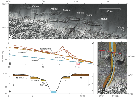
Fig. 1: A. Map of northern piedmont of the Tian Shan, Xinjiang Province, China.; B. Longitudinal profile with projected elevation of the Kuitun River and its alluvial; C. Profile across the Kuitun River and terrace ages.
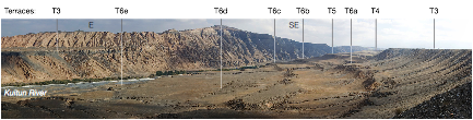
Fig. 2: Flight of Holocene terraces (T6a-e) in the core of the Dushanzi anticline (see Fig. 1D).