Reports: UNI853854-UNI8: Using Cosmogenic Nuclides to Evaluate Uplift and Erosion of the Guadalupe Mountains, New Mexico
Lisa M. Tranel, PhD, Illinois State University
Introduction
Conditions in the deep
crust and mantle must drive surface processes, however we need to improve our
understanding of the rates and timescales at which the deep earth and surface
systems interact. The scientific objective of this project is to investigate if
surface processes record the progression of extension and mantle processes at
rift zone margins. The Rio Grande Rift is an ideal region to investigate these
interactions due to results of deep earth observations. The Guadalupe Mountains
in western Texas and southeastern New Mexico are positioned on the eastern
margin of the Rio Grande Rift. Although the rocks of the Guadalupe Mountains
have been well studied for their relationship to petroleum sources and
reservoirs, recent faulting and sediment production via erosion is less well
understood. This study helps constrain the timing and spatial distribution of
topography in the Guadalupe Mountains to investigate the spatial variability of
erosional, tectonic and mantle influences. First, we are studying the spatial
patterns of landscape evolution in relation to faulting with geomorphic
analyses of the landscape completed with digital elevation models in a
geographic information system. The modeled results from digital elevation
models will be compared to field estimates of erosion rates quantified with
catchment averaged cosmogenic nuclide analyses. Second, we will constrain the
timing and rates of faulting and surface processes with cosmogenic nuclide
exposure ages along the western escarpment and individual faults.
Research Questions
The first problem we
focused on the spatial distribution of landscape evolution in the Guadalupe
Mountains influenced by faulting. Our specific hypotheses are: 1. Spatial
patterns of erosion will be faster at the center of the range where the
greatest displacement occurs, with decreasing erosion rates toward the northern
and southern tips. 2. Variable uplift and erosion is caused by regional propagation
of extension from south to north.
Methods and
Results
To investigate the first
problem, we collected sediment samples at the mouth of catchments to estimate
the catchment averaged erosion rates with cosmogenic radionuclides. We received
preliminary results from the Purdue PRIME Lab this week, but have not had time
to complete calculations to include in this report. We also analyzed elevation
datasets to determine the geomorphic patterns of landscape evolution related to
north-south position in the mountain range and position along fault segments.
Two types of geomorphic analyses were completed. The first investigated the
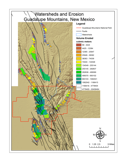
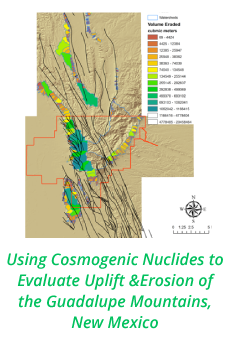
volume of material that was eroded from stream catchments throughout the range.
A digital elevation model was used to delineate stream channels and watersheds
throughout the Guadalupe Mountains. Initial, pre-erosional surfaces were
created above the catchments and the difference between the surfaces was used
to find the volume of material eroded. An erosion rate was calculated by
dividing the total volume by an estimate of exhumation initiation at 35 Ma
determined from apatite U-Th/He cooling ages measured in three bedrock samples
from the range. Across the entire range, the greatest volume of sediment was
eroded from the southern end of the range. Larger catchments are found near
more complex arrays of faults (Figure 1). A comparison between east and west
shows that average slopes are greater in east draining catchments than west
draining catchments.
The second geomorphic
analysis looked at the complexity of the stream channels. The streams were
traced in Google Earth to determine where most active flows were likely to
occur using different available time images. Channels were then assigned a
Shreve stream order number. The streams were brought into ArcGIS to determine
the lengths of stream segments. The lengths and order numbers were compared
from north to south along the western escarpment of the range and along
individual fault segments. Stream order numbers were higher along the fault
that created the western escarpment than the faults within the Brokeoff Mountains
to the west. This result suggests that evolution of the escarpment has been
active more recently than the other faults.
Continuing
Work
The remaining work will be
to analyze and summarize quantitative measurements of exhumation and uplift and
refine geomorphic analyses. The spatial patterns observed in the geomorphic
analyses above will be compared to catchment averaged erosion rates and bedrock
exposure ages along faults and the escarpment. We will also investigate if fault displacement is similar to the
timing of alunite mineral formation in cave deposits observed in the Guadalupe
Mountains based on cosmogenic exposure ages. We are
waiting for sample results from Purdue PRIME lab and have prepared a second
batch of samples to be sent out for analysis in October. Fieldwork in the
spring will allow us an opportunity to collect additional samples for
analysis over the summer.
Research Team
and Impact
This grant provided some
financial support to four undergraduate students. Three of the students, Tyler
Rothschild, Dakota Csanda, and Kacey Garber, helped process samples at Illinois
State University to prepare them for cosmogenic analyses at Purdue PRIME Lab.
One student, Kirsten Schaefer, completed the geomorphic analysis of stream
catchments with GIS. This grant also allowed me to take four students, Kacey
Garber, Christine Salinas, Dakota Csanda, and Tyler Rothschild to the field to
investigate field sites and collect samples. Christine Salinas completed an
analysis of stream networks in relation to fault positions with combined GIS
and Google Earth work as part of an independent study. During Spring and Summer
2015, these students working with me met on a weekly or biweekly schedule to
discuss research papers, progress with samples and the geologic background of
the field site. Christine Salinas, Dakota Csanda and Kacey Garber will be
presenting research posters at the Geological Society of America Annual Meeting
in Baltimore in November. Kirsten Schaefer received an extended internship with
the National Park Service, where she has been asked to apply her GIS skills.
 printer friendly