Reports: DNI853544-DNI8: Testing Models of Dune Field Pattern Formation in Ancient Aeolian Stratigraphic Successions - Permian Cedar Mesa Sandstone, Utah and Jurassic Norphlet Sandstone, Gulf of Mexico
 printer friendly
Project year 2 focused on collecting and analyzing core, geophysical and field data to develop an aeolian stratigraphic model that incorporates spatial heterogeneities related to the self-organization of wind-blown sand dunes. The primary activities included analyzing initial data collected during project year 1 from core and geophysical logs of the Norphlet Sandstone in the Gulf of Mexico and collecting additional Norphlet data. We also visited one of our field sites in Utah to collect preliminary data in preparation for our planned 2016 field campaign. Maria Gutierrez, who joined the team during project year 1, returned to the Alabama Geologic Survey to investigate additional Norphlet cores and is now wrapping up her Master’s thesis titled “Spatial variations in aeolian stratigraphic architecture of the Norphlet Formation, Soutwest Alabama”. She anticipates finishing by December of 2015. John Phillips, who was an undergraduate working with our group in project year 1, has begun a Master’s degree to continue his undergraduate research using RTK GPS and terrestrial lidar (t-lidar) to analyze aeolian outcrops.
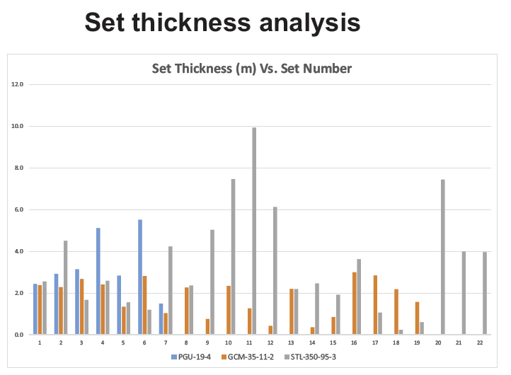
Norphlet Sandstone. The Norphlet Sandstone is an aeolian oil and gas reservoir in the Gulf of Mexico and presents an opportunity to develop and test our model with subsurface data. Maria, the graduate student leading the Norphlet project, has begun to synthesize the core and geophysical log data collected from her work at the Alabama core shed. She has developed four very detailed stratigraphic sections of over 700 ft of core, which document the size and distribution of different stratification types, the number of bounding surfaces and the thickness of the aeolian bedform sets. The detailed measurements allow a statistical analysis of the stratification in each core and comparison between cores to test how stratification varies away from paleo-highlands and in the inferred direction of sand transport. One interesting aspect of this research is that set thickness varies by proximity to highlands (Fig. 1). The most proximal aeolian units have overall thinner sets and those that are distal show thicker sets. Although set thickness is not necessarily a proxy for bedform size, these data could show a trend in the organization of the dunes from the upland source areas into the distal areas of the dune field. Modern examples reveal that dunes increase in size and organization away from source areas. These data were most recently compiled and presented at the 2015 Gulf Coast Association of Geological Societies meeting in Houston, Texas. Maria will continue her statistical analysis of the stratification, grain size and dip meter data to complete her thesis. Upon completion of her thesis, Maria may take on a Phd focused on petroleum research at Texas A&M University.
Figure 1. Set thickness shown on the vertical axis and set
number shown on the horizontal axis reveal that the most aeolian sets most
distal from the uplands (STL-350-95-3) have larger maximum set sizes than those
proximal to the uplands (PGU-19-4 and GCM-35-11-2).
Cedar Mesa Sandstone: John, the graduate student research lead
on the Cedar Mesa Sandstone, and PI Ewing traveled to Utah in October of 2014
to scan section of the Cedar Mesa Sandstone, a Permian aeolian unit that
outcrops near Canyonlands National Park. We setup an RTK GPS survey to
establish control points for our t-lidar survey and used the t-lidar to scan a
360 degree exposure of an aeolian outcrop. The aim of this 3 day field campaign
was to test our field methods and collect preliminary data in order to refine
our t-lidar processing and analysis. The campaign was very successful, we took
9 high resolution scans with a Leica Scanstation C10. One interesting aspect of
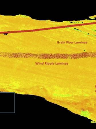
these data is that the stratification types can be discerned by analyzing the
intensity values of the data (Fig. 2). This may be an artifact of the grain
size and packing associated with the stratification types and the diagenesis
that follows the stratification types. In Figure 2, the grain flow
stratification show alternating high (orange) and low (yellow) intensity
values, whereas the wind ripple stratification show more uniformly high
intensity values. This analysis was presented at the 2015 Texas A&M
College of Geosciences Research Forum. John is continuing to work on this
dataset in preparation for a larger field campaign to Utah in the late spring
of 2016. This campaign will collect more t-lidar data and field samples for
slab and thin section analysis.
Figure 2: Intensity map of t-lidar data collected near
Hite, UT in the Permian Cedar Mesa Sandstone. Orange indicates high intensity
values and varies somewhat with stratification type. Grain flow stratification
show longer wavelength alterations between high and low values than do wind
ripple stratification types.
Professional Development: Project year 2 allotted a number
of opportunites for training and advancement. The research continues to broaden
the PI’s skillset by focusing on new technical methods and detailed analyses of
outcrop and subsurface data. His presentation of the DNI proposal are being
written for a SEPM special publication on autogenic dynamics in sedimentary
systems. Maria undertook another successful visit to measure core and presented
the synthesis of her work at the Gulf Coast Association of Geological Societies
in Houston, TX. John gained valuable experience in the field, as an
undergraduate, and presented his work at our college research forum. As an undergraduate
he developed valuable technical skills that helped him get on-board for a
Master’s degree here at Texas A&M. The last project year promises to be
interesting. The statistical analysis of the Norphlet data will help determine
how tractable a self-organization model is for subsurface data. The field data
will provide a more complete statistical data set to bridge the gap between the
analyses between subsurface, outcrop and geomorphology.