Reports: UNI253378-UNI2: Controls on Organic Carbon Accumulation, Burial Efficiency, and Hydrocarbon Content in Lake Sediments of the Boreal Forest-Tundra Ecotone, Labrador, Canada
 printer friendly
This study is examining a network of modern lakes which span the dramatic ecological gradient of the boreal forest-tundra ecotone in southeastern Labrador, Canada (Figure 1). By quantifying rates of organic carbon accumulation and burial efficiency in lakes of differing physical characteristics and ecological surroundings I aim to evaluate the effects of differing within-lake processes, watershed characteristics, and long-term climate and environmental changes on the accumulation of organic carbon in lacustrine environments.
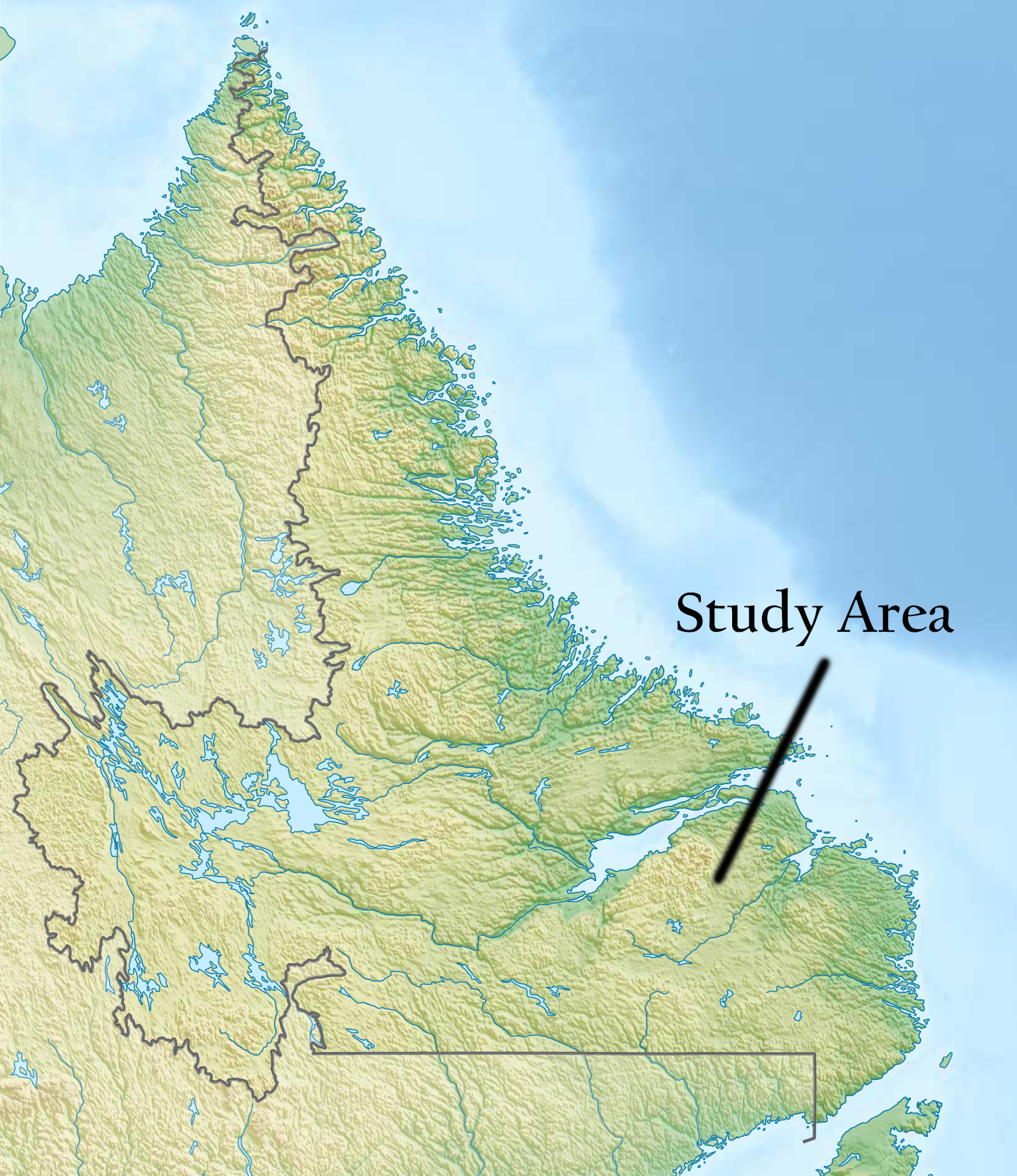
Figure 1. Regional map of Labrador indicating the study area in the eastern Mealy Mountains.
Following on the success of the first year’s field expedition the past year has focused predominantly on initial evaluation of the sediment samples collected in 2014. The two undergraduate students who participated in the 2014 field season both completed theses during the subsequent academic year. One student determined the organic carbon content of modern surface sediment samples in each of the lakes and evaluated these results in the context of a GIS based analysis of each lake’s morphometry and watershed characteristics. The other student evaluated a sediment core from Moose Lake and examined the history of lake productivity in the context of long-term regional environmental change. Both students presented their results at the 2015 annual meeting of the Northeastern Section of the Geological Society of America in Bretton Woods, NH.
The first year’s field work and preliminary laboratory analyses determined that in general, the lakes in the study area have exceptionally low productivity. Unexpectedly, we recovered complete post-glacial sedimentary sequences from cores collected from two of the lakes. Preliminary chronological control for the onset of organic sediment accumulation in these lakes is considerably younger than what might be expected based on the limited information about the regional deglacial history of the area. Consequently, a primary goal of the 2015 field season became the acquisition of complete post-glacial sedimentary sequences from additional sites in order to better constrain the regional environmental history. In addition, the 2015 field season was also designed to recover sediment traps, water temperature loggers, and automated weather stations deployed in 2014 and target additional lakes for sediment cores in order to ensure the broadest possible spectrum of lake and catchment characteristics.
In late June 2015 I returned to the Mealy Mountains field area for a 15 day expedition with two undergraduate students hired as field assistants. Overall, the 2015 field campaign was a resounding success. We recovered both weather stations and the majority of sediment traps and water temperature loggers. One lake was not reached in 2015 due to inclement weather and the mooring in another was destroyed by ice during the intervening winter. We surveyed and collected sediment cores from two entirely new lakes and four lakes previously surveyed or sampled in 2014. Two of these new cores are believed to contain complete post-glacial sedimentary sequences (satisfying one of our primary goals) and the rest complete the breadth of our sampling regime ensuring that we now have cores from which we can quantify long-term rates of organic carbon burial for the widest possible range of lake and catchment variations (Figure 2, Table 1). In summary, as a result of the two seasons of field work we have: 1) hourly air temperature records from both low and high elevation weather stations spanning 1 year, 2) hourly water temperature records from surface, mid and deep water sites in 6 different lakes, 3) sediment traps containing 1 year’s worth of sediment accumulation from 6 lakes, 4) long (>1 m and/or likely spanning several thousand years or more) sediment cores from 9 sites, and 5) complete post-glacial sedimentary sequences from 4 lakes in order help constrain the regional history of post-glacial environmental change.
The two undergraduate students who participated in the field work remain heavily involved in the project and both will be completing theses projects during the upcoming academic year. One of the students was able to leverage their involvement in the field work to secure additional funding through a Massachusetts Space Grant Consortium Summer Fellowship. This funding allowed the student to expand the overall research project to involve remote sensing of current vegetation cover and the evaluation of historical vegetation changes over the past 40 years using Landsat Imagery. These data are helping to better constrain the differences among the catchments of the study lakes and to evaluate the sensitivity of the region to recent climate change. The other student is focusing on the analysis and interpretation of the sediment core recovered from Spruce Lake, one of the sites from which a complete post-glacial sedimentary sequence was recovered. He will be evaluating the long-term variability of organic carbon accumulation during this period of significant climate and environmental change. Both students plan to present the results of their work at the upcoming Geological Society of America Northeastern Section Annual Meeting in Albany, NY in March 2016.
Support from the Petroleum Research Fund (PRF) has provided the PI an incredible opportunity to expand his research into a new geographic region and promises to generate new insight into the mechanisms that connect physical, biological, and chemical processes in lakes to the formation of distinct sedimentary deposits. The data and samples collected over the two-year PRF funding cycle will provide a wealth of opportunity for continued research by the PI. To help facilitate ongoing laboratory work and analysis of results obtained to date, the PI leveraged PRF support to gain additional funding through a Worcester State Mini Grant. These funds will cover laboratory analytical costs through the summer of 2016 with the goal of quantifying long term rates of carbon accumulation in all sampled lakes by this time.
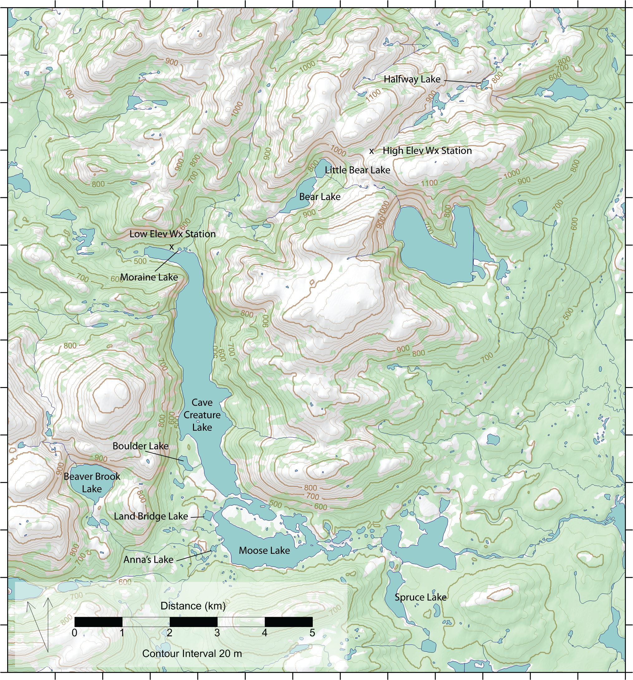
Figure 2. Map of the eastern Mealy Mountains depicting study area lakes