Reports: ND854670-ND8: A Theoretical and Field-Based Study on the Formation and Shape of Fluvial Levees
Doug Edmonds, Indiana University, Bloomington
During the first year of this grant we have made progress on both of those questions. Research activities include model development and field data collection. On the model development front we now have a working 1D advection-diffusion model of levee formation. The goal of this model is to explore controls on levee shape. Previous research is equivocal about whether levees are dominated by advection processes from the channel to the floodplain or diffusion processes. There is some suggestion that levees formed by either process look different. We plan to test the sensitivity of levee formation and the resulting shape under end-member scenarios of diffusion vs. advection dominated hydraulics.
Our model of levee formation assumed a straight reach of a laterally-immobile river whose orientation is parallel to the edges of a floodplain. The river adjacent to the floodplain has a given water depth and slope. The bed consists of different grain sizes. Each grain size is transported by the flow in accordance with an equilibrium vertical concentration of suspended sediment that varies vertically as defined by the Rouse profile. Most of the suspended sediment is carried near the bed and the concentration nonlinearly decreases closer to the surface. The sediment caliber and concentration available for advection-diffusion across the floodplain is found by integrating the channel concentration from the levee top to water surface. In our model formulation we assume that the main river channel and the sediment supplied to the floodplain from the channel does not change with time. The movement of material from the channel is governed by the classic one-dimensional advection-diffusion equation.
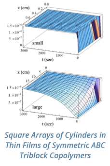
Initial modeling results are promising. A series of >500 model runs show how levee cross-sectional profile varies as a function of advection and diffusion processes (see TOC for reference). The next step is to perform sensitivity analyses to determine whether advection or diffusion is the controlling process and then compare the numerical results to field data.
The field data come from two sources. First, we have used recently collected LiDAR data from the state of Indiana to analyze levee shape and occurrence from two river systems with different sediment character. The purposes of these field data are to test the basic trends on levee shape and occurrence from the model.
For our field data we chose a 30-km reach of the West Fork of the White River and a 50-km reach of the Muscatatuck River in Indiana. Each of these rivers have different sediment character because the Muscatatuck drains a loess-dominated region of Indiana, whereas the West Fork of the White River is dominated by coarser outwash sediment.
We collected sedimentology data at bankfull stage at several locations where bridges span each river. Depth integrated suspended sediment samples were taken with a US DH-59 sampler. We then measured suspended sediment concentration from these samples. We filtered our samples through 2.5 micron Whatman filters to remove the suspended fraction and then dried and weighed that fraction on a high precision scale. Grain size of the suspended load was determined with a microscope. We also collected bed grab samples from the same location. We calculated median grain size of the bed material from the samples by measuring grain size on a Malvern Mastersizer 3000 laser particle size analyzer. The fraction greater than 2 mm was removed, and sorted with sieving. The Malvern Mastersizer measures volume percentages, and we converted volume to weight percent assuming spherical grains of quartz. The next step is to gather hydrology data for both rivers from USGS operated stream gages. From these gages we calculate can flooding characteristics.

