Reports: UR854400-UR8: Influence of Anisotropy on Dynamic Rupture During Incipient Fault Zone Development
Joseph L. Allen, Concord University
Purpose of Study. The geometry of faults and their
associated damage zones controls fault-rock properties, permeability, and fluid
flow; these factors strongly influence their potential as seals or migration pathways
in conventional petroleum reservoirs. They also control the strength of
basement faults and their potential for reactivation, which can influence reservoir
architecture. Faults accumulate displacement at variable rates spanning several
orders of magnitude, encompassing a continuum between slow aseismic creep and
standard earthquake slip accommodating high-velocity dynamic rupture. A significant component of the
accumulated displacement and damage is gained from propagation of the latter;
however, little is known of the internal geometry of high-velocity dynamic
ruptures within fault zones or what geometric conditions favor their
development. The goal of this project is to document the internal structure,
kinematics, and dynamics of fault-zone segments that hosted high-velocity
dynamic ruptures. We focus on a unique record of rupture recorded by
pseudotachylyte (solidified frictional melt) preserved in a fault zone in
western Greenland. The ruptures are
developed in foliated, high-grade metamorphic rocks that are characteristically
layered into 1–10-m-thick bands that emulate the geometry of sedimentary
beds. Since pseudotachylyte is the
only clear record of high-velocity rupture that is mappable
at the fault-system scale, this field site serves as a unique analog for study
of rupture propagation in sedimentary strata.
Year 1 Accomplishments. Pseudotachylytes from the Ikertooq thrust zone in western Greenland were first
characterized and mapped by Grocott (1981, J.
Structural Geol.) as dextral and sinistral
strike-slip faults concentrated within three 4–5-km-long brittle fault
zones. The work introduced the classic concept of the pseudotachylyte
generation zone as a system of paired shears bounding a complex damage zone. The Ikertooq
exposures were subsequently utilized as a model for sidewall ripouts in strike-slip faults (Swanson, 1989, J. Structural Geol.). Our ongoing
mapping of these faults on Sarfannguit and outlying islands and skerries in the Ikertooq fjord
and Davis Strait has: (1) Extended the known length of the pseudotachylyte
system from a few km to more than 13 km, (2) defined a previously unknown
fourth fault zone southeast of the main system, and (3) led to a revised
kinematic model.
In the 2015 field season, two undergraduates and the PI mapped the
southern three of the four fault zones. Our early results demonstrate that the Ikertooq brittle faults are not a strike-slip system. Instead, offset dikes and slickenlines
with steep rakes preserved in pseudotachylyte show that the faults primarily
developed as dextral oblique reverse faults with top-to-southeast displacement. These faults are concordant with straight-banded
foliation in Archean and Paleoproterozoic host gneisses (mean strike/dip 240/50
NW). In some vertical exposures, we
observed meter-scale, subhorizontal fault ramps that
cut foliation and confirm kinematic relationships. The NW-dipping faults are
commonly linked by 1-4-m-long, subvertical, dextral strike-slip relay faults
that strike 280 degrees and accommodate a right-stepping
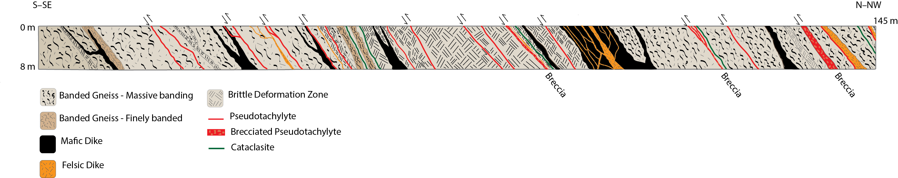
fault geometry. Displacement on these faults controls the distribution of thick
(4–15 cm) pseudotachylyte fault veins and spectacular
10–80-cm-thick pseudotachylyte breccia zones (Fig. 1).
The pseudotachylyte-bearing faults are dispersed
across the width of each of the 100–250-m-wide fault zones with a typical
density of 1–5 faults/10 m (Fig. 2). Many faults are localized at the
margins of 0.2–3-m-thick Paleoproterozoic mafic dikes that are subparallel with gneissic foliation. On a broader scale,
the four fault zones are localized within high-strain zones that strike 240
degrees and are characterized by transposed foliation and mesoscopic
isoclinal and sheath folds with moderately west-plunging axes. Gneisses between
the high strain zones strike 220–230 degrees with locally shallower dips
(40 degrees). We also documented subordinate veins of older mylonitic
pseudotachylyte indicating a long history of localization of seismicity in the Ikertooq zone. The two undergraduates who participated in the Greenland
field mapping during summer 2015 will continue to work on the project during
their senior year (2015-16).Our
2015 results will be presented at the Geological Society of America annual
meeting in Baltimore, Maryland.
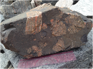
Figure 1. Hand
sample from a thick pseudotachylyte breccia zone formed during a single rupture
event; 15 cm protractor for scale.
Detailed geologic mapping in 2015 demonstrated that the breccia zones
were systematically distributed across the fault zones. They are commonly found
in 2- to 10-m-long segments in top-to-south reverse faults and are terminated
at strike-slip fault stepovers that serve to link reverse-fault
segments. Ongoing work will focus
on further developing a mechanical model to explain their origin, as they either
represent major episodes of frictional melting as a result of large slip, or
fluid ponding in an over-pressured fault.
Figure 2. Cross section of one of
the three major fault zones mapped in 2015.
 printer friendly