Reports: ND853814-ND8: Investigating the Buffering Effect of an Active Piedmont in Routing Sediments to the Foreland
 printer friendly
Introduction
The sediments shed into a foreland basin
reflect the tectonic and climatic forcing of erosion in the upper reach of the
drainage system convolved by the ‘transfer function’ resulting from transient
storage and episodic transport associated with sediment routing. The piedmont
of a mountain range plays a particularly important role in that regard as it
lies at the transition from the erosive mountain domain to the depositional
environment of the basin. It is the locus of a complex coupling between surface
processes, thrusting and folding, autocyclic river aggradation, and incision.
The project therefore focused on the role of the piedmont on sediment routing
based on the detailed analysis of a remarkable example.
Study area
We focused the study on the North Tianshan piedmont because:
1- Active folding and thrusting is clearly expressed in the geomorphology.
2- The rivers flowing across the folds have entrenched by more than 200 m since the early Holocene leaving a record of river entrenchment and narrowing of the floodplain in the form of well-preserved river terraces, thereby providing well exposed sections for detailed structural and stratigraphic investigations.
3- The sedimentation history over the last Myrs is well constrained from magnetostratigrahic studies.
4- Oil exploration seismic profiles are available providing constraints on the deep structure..
5- Deformation rates are moderate, so that uplift and sedimentation rates (about 0.2 mm/yr over the last 10 Myr) are of similar order of magnitude, favoring a good record of deformation by growth. This makes it possible to describe quantitatively the history of sedimentation and deformation over the last ~10Myr.
Numerous abandoned terraces provide an exceptional record of recent fold development (for example along the Kuitun River; Fig. 2). Similarities between main geomorphic units along the piedmont seem to indicate that the whole region underwent the same evolution at least through the last 10-100 kyr, with alternating periods of fan aggradation and river entrenchment dictated by climate change. As a result, terraces with Holocene ages but also much older ones (100 ka and 200 ka) are relatively well preserved and provide useful constraints on cumulative deformation over different time periods. At present the active channel is entrenched by about 200m into the late glacial-early Holocene fan surface (fig. 1). As a result, the coarse gravel that were deposited at range front is now further transported downstream feeding an prograding fan which now lies about 30km from the range front. Such alternating phases of fan aggradation and reincision must have occurred repeatedly in the past and affected the geometry and stratigraphy of the foreland units. These units are exposed along the Kuitun river due to the recent deep river entrenchment. Work Done
- We have documented the alternating phases of fan aggradation and river incision which are well preserved in the geomorphology and alluvial deposits of the study area (Figure 1). To complement existing age data on the terraces, we worked in collaboration with Edward Rhodes (UCLA) and Julien Charreau (CRPG, (France) to date the various terraces in the study area, with Optically Stimulated Luminescence (OSL) and cosmogenic nuclides techniques respectively. The results from the field work are presented in a manuscript to be submitted (Malatesta et al, GSAB, in prep).
- We have developed a 1-D numerical model for bedrock rivers with dynamic alluvial cover and adjustable channel width (Malatesta et al, 2016). The model accounts for the fact that river entrenchment reduces the capacity of a channel to erode laterally, thereby favoring vertical incision. - We have developed a model of sediment transport and mixing (Malatesta, Berger and Avouac, to be submitted to JGR-Earth Surface Processes).
- We reported a fundamental morphologic contrast between the north and south alluvial piedmonts of the Tianshan. Under the same climate and the same tectonic regime, the northern rivers are deeply entrenched by up to 300 m in the piedmont, while the southern rivers are shallowly entrenched, if at all. We documented the imprint of glacial erosion and found that incision of the piedmont coincides with catchments where the upper valley has a wide bottom (u-shaped) and the lower valley is a narrow gorge. The disruption of the routing system results in a non-linear signal transfer. Ssmall climatic forcing can therefore affect significantly sediment routing and mixing (Malatesta and Avouac, to be submitted to Geology).
-As a side project on another study area we developed a model of sediment accumulation on the Zagros foreland basin (Pirouz et al, in review). This project was led by postdoctoral fellow Mortaza Pirouz.
Personnel
This research was carried out at Caltech by the PI, Jean-Philippe Avouac, a graduate student working 70% on this project (Luca Malatesta) and collaborators from other institutions in China, France and the US.. Graduate student Luca Malatesta has given presentations in a number of conferences and has been offered a postdoctoral position at UC Santa Cruz. The grant has allowed PI Avouac to develop a research activity on erosion and sediment transport to foreland basins. In addition to publications directly related to the ACS-PRF grant the PI got involved in other research projects in the same area of research. This output shows that this area of research has become a main thrust in the research portfolio of the PI.
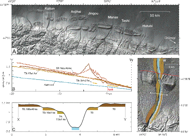
Fig. 1: A. Series of incised alluvial fans and active anticlines with the name of the main rivers in the northern piedmont of the North Tian Shan, China. (SRTM); B. Longitudinal profile with projected elevation of the Kuitun River and its alluvial terraces, positions of V-W marks in D (SPOT DEM); C. Profile across the Kuitun River and terrace ages) (SPOT DEM); D. The Kuitun river, flowing north.
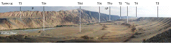
Fig. 2: Flight of Holocene terraces (T6a-e) in the core of the Dushanzi anticline (see Fig. 1D for location). For scale, the terrace T3 lies ca. 140 m above the present river bed.