Reports: DNI855161-DNI8: Middle to Late Jurassic Paleogeography, Western Colorado
Sally Potter-McIntyre, PhD, Southern Illinois University
This project has produced exciting preliminary results that are detailed below. Additionally, two students (one Ph.D. student and one M.S. student) have been supported this year. An additional M.S. student has participated in field work this past summer. Both the students and the PI have conducted field and laboratory investigations that resulted in three professional presentations at the GSA national meeting in Baltimore last October.
The purpose of this investigation is to better understand the landscape evolution of southwestern Laurentia during Mesozoic rifting of the supercontinent Pangea and the opening of the Gulf of Mexico to further our understanding of the development of the Piceance and Paradox Basins. Additional investigation has gone into investigating the environmental conditions during the deposition of the Cretaceous Mancos Shale in the Piceance Basin to better understand the controls on organic matter accumulation during deposition and early diagenesis for this source rock.
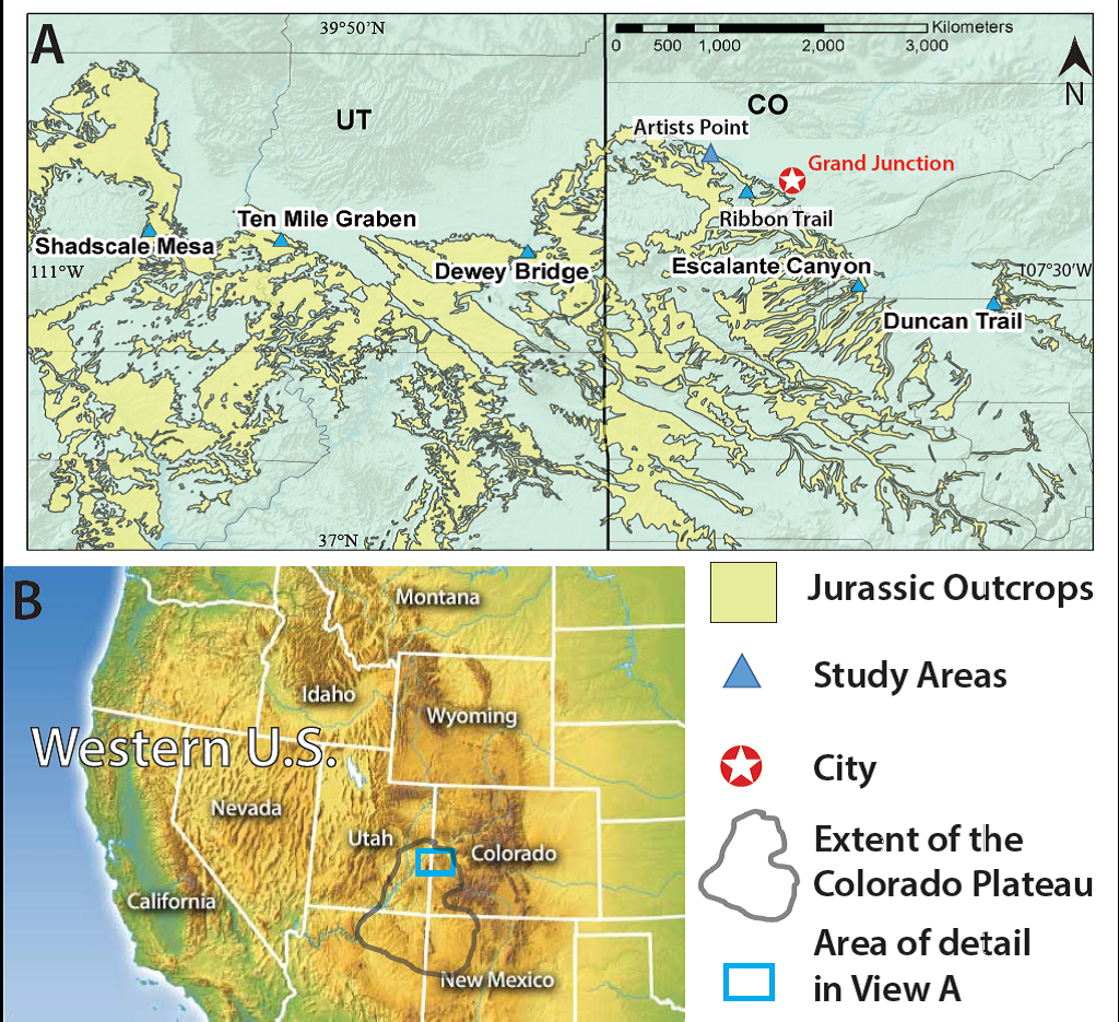
One of the major discoveries resulting from this research is a presentation of the first U/Pb age dating of detrital zircons from the Middle to Late Jurassic Entrada Sandstone, Wanakah Formation, and Tidwell and Salt Wash Members of the Morrison Formation. Detrital zircon geochronology results show a marked increase in ca. 523 Ma grains (compared to most Mesozoic sediments on the Colorado Plateau) that begins abruptly in the Wanakah Formation and continues into the basal Marker Bed A of the Tidwell Member of the Morrison Formation. U/Pb ages and petrography suggest that the Wanakah Formation was sourced, in large part, from the McClure Mountain syenite on the southwestern flank of the Ancestral Front Range (Fig. 1). This abrupt change in provenance occurred due to stream capture and drainage reorganization that input a large amount of water into the basin and caused a shift in depositional environment from the eolian Entrada Sandstone to the hypersaline lake environments of the Wanakah Formation and the Tidwell Member. Additionally, stratigraphic, petrological, and detrital zircon analyses suggest that the contact between the Wanakah Formation and the Tidwell Member of the Morrison Formation is conformable, and the previously interpreted J-5 unconformity is likely not present in western Colorado. The stream capture and drainage reorganization that created the lake system recorded in the Wanakah Formation and the Tidwell Member likely evolved into the major fluvial system that deposited the Salt Wash Member of the Morrison Formation. The evolution of paleodrainages and provenance are important to understand because they help to constrain landscape evolution across southwestern Laurentia, and these insights can help to illuminate the influence of tectonic and sediment controls on depositional environment.
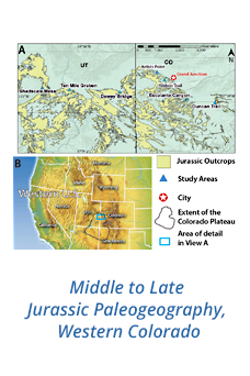
Research is continuing on the Wanakah Formation and adjacent units to test whether these initial results are evident throughout the study area of western Colorado and southern Utah. Additional samples (n=10) from two additional sections (Duncan Trail and Dewey Bridge; Figure 1) have been characterized and show that the McClure Mountain syenite is a major contributor to the basin and present in both western Colorado and eastern Utah (where the Wanakah Formation is typically not considered present). DZ and field analysis results from Dewey Bridge show that approximately 1 m of Wanakah Formation is present at the top of the Entrada Sandstone in that area. The J-5 unconformity is likely not present in any of these study areas and is more localized to the San Rafael Swell region than previously interpreted.
Another thrust of this research is to characterize the Mancos Shale as a potential unconventional gas reservoir in the Piceance Basin by doing a comprehensive study of the amount of organic matter (OM) accumulated in the shale. Traditional field methods were used to take a measured section of a Mancos Shale outcrop in western Colorado. Bulk geochemistry, rock evaluation, and petrographic analysis was performed to quantify levels of organic matter accumulation. Two major questions were posed: 1) Did the redox conditions present during deposition serve as the primary control on OM accumulation? and 2) How viable is the Mancos Shale as a petroleum reservoir within the Piceance Basin?
Paleo-redox conditions present at the time of deposition were evaluated to determine if there is evidence for a stratified water column. This is accomplished using C/S, C-S-Fe relationships, and the degree of pyritization (DOPT). Oxic, dysoxic, and anoxic are types of redox conditions that represent oxygen levels at the bottom of a water body and are categorized as thus; 8.0 –2.0, 2.0 – 0.2, and 0.0 ml O2/l, respectively (Tyson & Pearson, 1991). In order to ascertain the influence of other environmental factors on OM accumulation, paleoproductivity and clastic influx were also evaluated. The ratio of organic carbon to total phosphorus (Corg/Ptot) is used for a proxy of paleoproductivity; and Ti/Al and Si/Al ratios are used to appraise the influence of clastics during deposition.
In order to ascertain the viability of the Mancos Shale as a petroleum reservoir, complete source rock analyses was conducted. This includes total organic carbon (TOC), hydrogen index, kerogen typing, source rock potential, and maturation indicators. Whole-rock quantitative data were also acquired for 64 major, minor and trace elements. Fourteen samples were crushed to minus 20-mesh and minus 60-mesh for petrographic and geochemical analysis, respectively. Rock Eval was performed on the samples by GeoMark Research Ltd using about 5 g each of a 60 mesh shale sample.
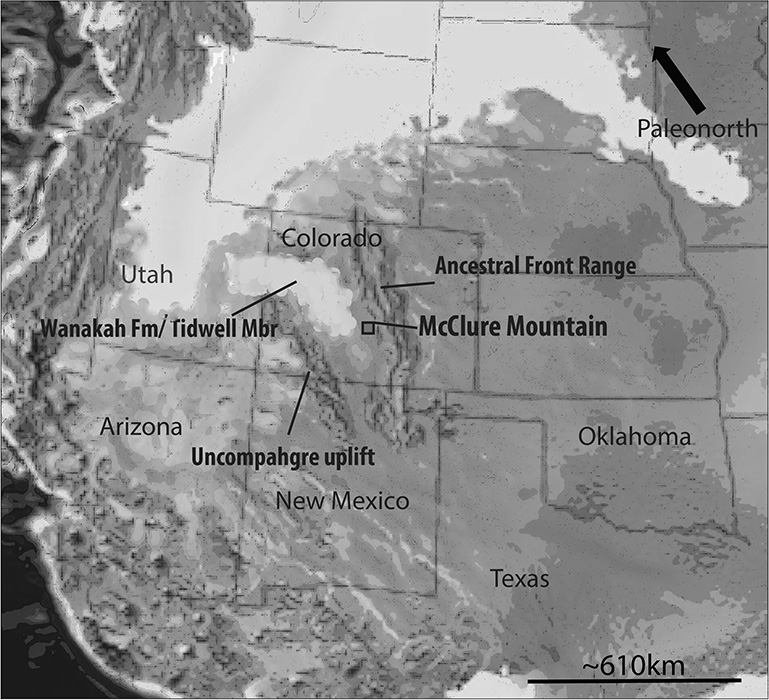 Figure
2. Circa 160 Ma paleogeographic reconstruction using base map from Blakey
(2014) and data from this research and Dickinson and Gehrels (2008, 2010) for
interpretation. The McClure Mountain syenite provided much of the sediment to
this basin. Additionally, these units were deposited in a large hypersaline
lake system that was episodically desiccated.
Figure 2. Study area.

