Reports: UNI853854-UNI8: Using Cosmogenic Nuclides to Evaluate Uplift and Erosion of the Guadalupe Mountains, New Mexico
 printer friendly
Introduction
El Capitan peak rises above flat salt basins to the east and plains to the west to define the southern limit of the Guadalupe Mountains. Resistant bedrock and faults created steep and distinct escarpments surrounding the mountains beginning in western Texas and extending north into southeast New Mexico. Regional extension to the west within the Rio Grande Rift likely influenced the shape of the landscape, but the history of tectonic exhumation in the Guadalupe Mountains remains unstudied. As the scientific community strives to understand the mechanisms that cause rifting in this region, we can use surface features to explore the extent of mantle influences on the crust. The scientific objective of this project is to investigate the timing and controls of surface processes and their relationships to regional uplift, extension or underlying bedrock. First this study investigates the spatial variability of erosion preserved in the topography using longitudinal profiles and bedrock characteristics. Second, cosmogenic nuclides provide quantitative estimates of erosion rates within channels and across the western escarpment.
Research Questions
This study consists of two parts to understand the evolution of the Guadalupe Mountains landscape:
1. How do climate, tectonics, and rock properties influence topographic features in the Guadalupe Mountains?
2. What are exposure ages and erosion rates along the western margin of the Guadalupe Mountains?
Methods and Results
We investigated the topographic features with a combination of field observations and digital analyses in a geographic information system (GIS). In the field, we observed and assigned rock strength values with a Schmidt hammer, rock weathering, and joint spacing and width characteristics. Those observations were compared to slope, concavity, and knickpoint positions in stream channel longitudinal profiles. Thus far, we identified several knickpoints in Pine Springs and McKittrick Canyons. We suggest that four different mechanisms created the knickpoints observed so far (Figure 1). Where the stream channel crosses a change in rock strength or unit boundary, a geologic knickpoint formed. A fault created at least one knickpoint in McKittrick Canyon. Knickpoints formed at the confluence of stream tributaries. Tectonic or climatic events may form migratory knickpoints.
We collected samples for cosmogenic nuclide analyses along the western rim escarpment to quantify the exhumation processes active in the Guadalupe Mountains. We collected bedrock samples from high and low elevation surfaces on several mapped fault segments (Figure 2) on the western margin of the range. We sent the samples to the PRIME Laboratory at Purdue University for processing and accelerated mass spectrometry analyses (AMS). We received results from three samples displaying exposure ages ranging from ~30-100 ka.
Continuing Work
Our work is still ongoing as we await final sample results from the Purdue University PRIME Lab. We will calculate erosion rates for at least 10 remaining samples once we receive final isotope concentrations from the AMS analyses. We also continue to analyze the topography with digital elevation models to understand catchment erosion patterns.
Research Team and Impact
This grant provided support to five undergraduate students and two graduate students. The undergraduate students assisted with sample collection in the Guadalupe Mountains and sample processing at Illinois State University. Both graduate students, Audrey Happel and Samuel Schoenmann, also participated in the field excursion to collect data for their projects. Audrey worked in the PRIME Lab at Purdue University for two weeks to process her samples, tour the accelerated mass spectrometer facility, and learn detailed information about cosmogenic nuclide analysis procedures. Audrey and Samuel both presented their preliminary results at the Geological Society of America (GSA) Annual Meeting in Denver, Colorado on September 26th, 2016. Each of the undergraduate assistants were included as coauthors on one or both of the posters. Dakota Csanda, Jeremy Neundorff, and Kacey Garber also attended the GSA meeting. Kirsten Schaefer graduated with her Bachelor of Science degree in Geology and is currently enrolled as a graduate student at Missouri State University.
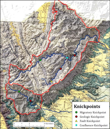
Figure 1. Geologic map over a shaded relief map displaying the observed knickpoints in Pine Springs and McKittrick Canyons. The watersheds for both canyons are outlined in red. The channels where profiles were constructed are shown with blue lines. Image by Samuel Schoenmann.
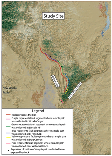
Figure 2. Aerial image of the Guadalupe Mountains. Fault locations were based on the New Mexico state geologic map and the geologic map of the Guadalupe Mountains National Park area. Image by Audrey Happel.