Reports: DNI853891-DNI8: Interactions of Fluvial Delta Island Aggradation with Organic Matter Deposition and Coastal Nutrient Export
 printer friendly
The impact of this grant on the PI’s career and on participating students has been productive, and substantial. This project is providing a fantastic opportunity for all the participants to adapt their prior knowledge of porous media to the important questions of “real time” ecosystem carbon and nutrient balances, and how those processes are necessary controls on the deposition and geologic preservation of carbon stores.
Project participants have included: the PI, a female, early-career STEM faculty member, first at the University of Texas at Austin (UT) and now at Washington State University (WSU); and Peter Zamora, a minority (Asian) postdoctoral scholar, formerly earning a PhD at UT, now a postdoc at WSU, and soon to be a tenure-track faculty member at the University of North Carolina at Wilmington. The professional growth opportunity this project has provided to this postdoc was instrumental in broadening his “toolbox” of research skills and aiding him in landing a tenure-track faculty job to continue his research and teaching contributions on coastal-margin topics. This project has also enabled synergy between the new work by this postdoc and an ongoing collaboration I have been involved in. This collaboration, with my former student Brittany Smith, has involved finalizing complementary analysis of previous field work on the sediment stratigraphy and organic matter (OM) preservation in a young prograding delta.
Specific Research Progress:
In the original proposal, three tasks were identified as key steps toward advancing our understanding of the co-evolution of delta island aggradation, OM deposition, and coastal nutrient export (which then fuels adjacent marine productivity and OM deposition). These were to: (1) Identify the co-depositional history of organic and clastic contributions to delta island sediments at the Wax Lake Delta, Louisiana, (2) Use remote sensing image analysis to relate historical island and vegetation extents as a step toward spatially-explicit sediment-and-OM deposition modeling, (3) Quantify the hydraulic and nutrient dynamics that support OM production and preservation in delta island sediments and so also improve estimates of the unconsumed nutrients exported to marine systems.
Regarding tasks 1 & 2, we have completed field work and have nearly completed manuscript preparation linking sedimentation, OM deposition, island geomorphic development, and vegetation patterning at two scales, that of an individual delta island and that of the whole delta. The first paper, on the island-scale, will be submitted this fall. An excerpt from the draft abstract follows:
This study investigated spatial and temporal correlations between vegetation succession, OM burial, and sediment accumulation at the Wax Lake Delta in Louisiana. We established a 2500 m long transect along the western levee of Pintail Island, capturing the full range of island elevations and the transition from bare sediment to herbaceous plants and trees. Sediment cores (50-100 cm deep) from this transect were analyzed for particle size, OM content, and bulk density, and dated using 210Pb. The sedimentation rates and composition trends over time were compared to remote sensing-based analyses of temporal changes in island topography and flooding frequency derived from historical Landsat images. At all but the youngest sampling site, sediment cores showed a significant decrease in OM content and a significant increase in grain size with depth. The total OM contribution to vertical growth was not sufficient to account for all the elevation change required to achieve the differentiation from low marsh to high marsh deduced from the historical Landsat analysis. Mineral accumulation rates suggested that elevation growth was accelerating or holding steady over time, in contrast to deltaic theory suggesting rates should slow as elevation increases. We propose that this discrepancy is the result of enhanced mineral sedimentation due to the presence of vegetation. These results provide an empirical foundation for future mechanistic models linking mineral and organic sedimentation during deltaic deposits’ development.
A second manuscript in preparation applies the same historical remote sensing analysis of how the delta islands have developed over the last few decades to assess at a larger spatial (whole-delta) and longer temporal scale how patterns of island growth (i.e. sediment deposition) and marsh development (i.e. hotspots of OM production and burial) have interacted in this young, prograding system.
Task 3 has been the focus of our most recent work, including substantial new field data collection and numerical modeling. This ambitious task was to quantify the hydraulic and nutrient dynamics that support organic matter production and preservation on delta islands and the unconsumed nutrients exported to marine systems. This work is ongoing during the next project year. Results to date include quantifying sediment permeabilities (Fig. 1), developing a fully coupled 3D numerical model of surface and subsurface fluid flow through the delta island sediments (Fig. 2), and completing the first inventory of carbon and dissolved nutrient pools within the deeper sediments of the delta system not accessed by prior studies (i.e., deeper than the top 10 cm previously studied). The numerical model is successfully demonstrating routing of surface water, and so dissolved carbon and nitrogen (C&N), through the channel-island-lagoon network and through the island porous medium. We are using model results to quantify a wide temporal and spatial scale of groundwater-surface water mixing and residence times which will substantially affect the cycling and distribution of C&N, and therefore the relative potential for C to be preserved in situ. A manuscript on these modeling results is currently in preparation, and preliminary results being presented at the fall 2016 Geological Society of America meeting. Next we are working to combine our flow modeling and field chemistry to better constrain the mass fluxes of water, salt, nutrients, and dissolved organic carbon across surface-ground and delta-marine interfaces, to move toward an improved mass balance of C&N for the delta that accounts for previously neglected accumulations and consumptions within island sediments.
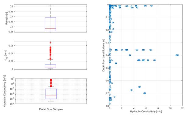
Figure 1. (Left panels) Sediment porosity and effective grain size (d10) used in calculating permeability. (Right panel) Hydraulic conductivity depth-distribution.
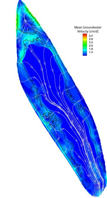
Figure 2. Simulated mean groundwater velocity (colors) in the sandy island subsurface. White average horizontal flow paths showing net solute trajectories.
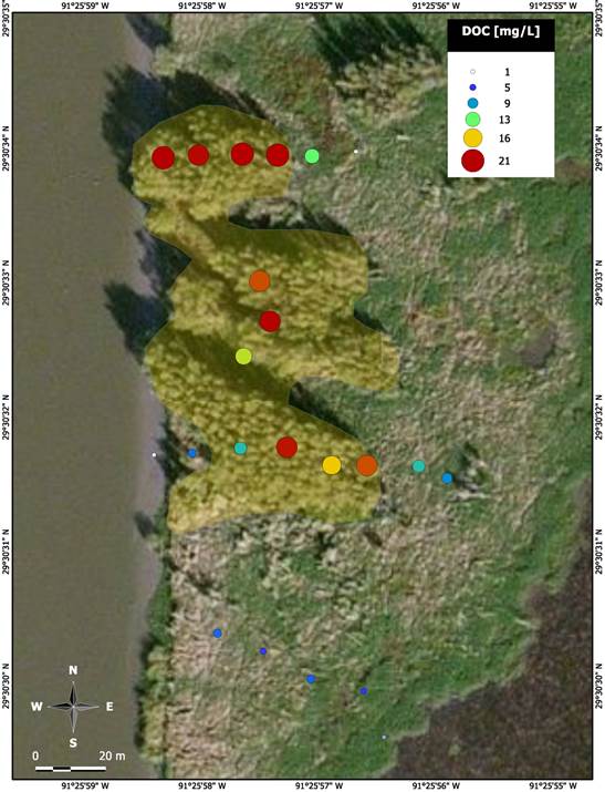
Figure 3. DOC porewater averages. Yellow - willow cluster.