Reports: DNI854376-DNI8: Petroleum Generation in Geologically-Young Lacustrine Rift Basins: Integrated Stratigraphy, Experimental Geochemistry, and Basin Modeling
 printer friendly
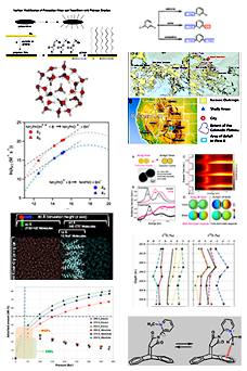
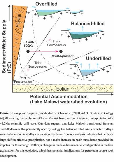 The project team has made important progress on the analysis of Lake Malawi scientific drill cores. The detailed stratigraphy, inorganic geochemistry, organic geochemistry, and maturity measurements have been substantially advanced or completed since the last annual report, which are important milestones that will allow for several of our planned publications to move forward. The culmination of our efforts over the past year is a new publication in PNAS (Ivory et al., 2016) that uses our interpretation of stratigraphy and geomorphology as a foundation for understanding patterns of tropical environmental change and adaptive radiation over the past ~1.2 Ma in Lake Malawi. One key aspect of this paper was the recognition that lake basin type (sensu Carroll and Bohacs, 1999, Geology) has evolved considerably at Lake Malawi in the Quaternary, from an overfilled system to the deep balanced-filled lake that exists today. Variability in parasequences and the identification of a xenoconformity (a chronostratigrapically significant bounding surface that shows little or no evidence of a major time gap; cf Carroll, 2014, GSA Annual Meeting) were the first pieces of evidence that led us to closely examine the potential for a major change in the hydrological configuration of the basin; such a change is consistent with vertical biofacies (ostracodes, pollen, algae) patterns. Our model suggests that the Ruhuhu River, which today flows into the lake and forms an accommodation zone delta on basin’s northeastern margin, may have previously served as the lake’s outlet. Through an analysis of digital elevation models and satellite images, we interpret that the Ruhuhu River drainage has been uplifted, which appears to have caused the course of the river to reverse its flow. Today, the Ruhuhu watershed is marked by bedrock-incised meanders, tributary orientations suggestive of flow to the east, and several prominent water gaps, which together provide further evidence for recent tectonic modification. This mechanism adds a novel scenario to the lake basin model proposed by Carroll and Bohacs (1999) when considering the extant African rift lakes, which serve as both frontier petroleum basins and analogs for lacustrine rift plays globally. We suggest that evolution of the Lake Malawi watershed by extension-related Quaternary faulting effectively closed off the Ruhuhu River valley as a viable outlet, which caused lake level to rise until a new sill elevation at the southern axis of the basin (i.e., the Shire River) was reached. Thus, accommodation for water and sediment was increased without the need for substantially increasing either subsidence or rainfall. Our chronological model suggests that this change took place at ~800-700ka. We have developed geochemical provenance data to help support this interpretation that includes both fine grained (via XRF and INAA) and coarse grained (via U-Pb detrital zircon geochronology) sediments. Notably, the rare earth elements in Lake Malawi sediment are higher (relative to PAAS) than other lacustrine source- or proto-source rocks from China, Argentina, and the USA; we are developing this comparison as a separate manuscript for publication, with an anticipated submission in Q1 2017 to the journal Geochemical Transactions. Some minor chemostratigraphic shifts in elemental abundances (e.g., %Al, Ce/Ce) at ~800-700ka may also reflect a change in sediment source; we are actively investigating this possibility. The Ruhuhu watershed contains considerable Karoo rift (late Pennsylvanian-early Permian; Wopfner and Kreuser, 1986, Palaeogeography, Palaeoclimatology, Palaeoecology) sedimentary rocks, upon which lateritic soils have developed – these characteristics are unique within the greater Lake Malawi watershed and provide a basis for this interpretation. U-Pb detrital zircon ages provide more compelling evidence for a change in provenance. Although our analysis is presently limited to two samples (sands are very uncommon in the drillcore), marked differences exist in the age spectra from samples situated above and below the ~800-700ka level in the core. Karoo-aged sedimentary rocks contain a diverse assemblage of facies, to include glacial tillites. Notably, the sands older than ~800-700ka yielded very old zircon ages, which most likely reflect contributions of weathered Ubendian metamorphic basement, which is widespread around the lake. However, sands above 800-700ka yield a prominent and nearly unimodal peak of younger zircons, which may relate to Mozambique belt basement rocks carried by continental ice sheets to the Ruhuhu watershed. We anticipate developing this interpretation more in the coming year, with a manuscript submission to the journal Geology planned for Q2 in 2017. Clearly, the lake-basin type changes we have interpreted have important implications for exploring petroleum systems in Lake Malawi and analogous, more ancient rift basins. If our interpretations are correct, more gas-prone proto-source rocks are likely to have accumulated below ~200m below the lake floor, whereas organic facies above this stratal level are more likely to produce oil upon burial and maturation. Our research on artificial maturation using gold sealed tube pyrolysis is still under development, which motivated our request for a no-cost extension for another year. The first batch of experiments was unsuccessful due to rupturing of gold tubes during stepped heating. The sealed tube pyrolysis laboratory at the USGS was then unexpectedly requested to move its location, which unfortunately resulted in delays to the follow up experiments. We are committed to completing these experiments when the lab is back online. Kinetics information derived from the experiments will be utilized in 1D Trinity/Genesis basin models, which will utilize core stratigraphy, thermal maturity (%VRo), and available seismic data.