Reports: DNI854673-DNI8: Influence of Mantle Processes on the Formation of Petroleum-Bearing Basins in the Central Rocky Mountains, Western U.S.A
 printer friendly
Research activities
During the second year of the project, PhD student, Min Gao, has summarized the spatiotemporal patterns of lithosphere stiffness in the Powder River, Bighorn, Wind River, and Green River basins, and published a paper. Jenna West, a MS student, has initiated modeling landscape evolution in the central Rockies for the period of latest Cretaceous and Cenozoic. Dr. Lin Li joined in the project in August 2016. Lin started examining how mantle dynamic process related to the subduction of the Tethys plate and Indian plate undereneath Eurasia may have influenced the formation of intermountain basins on southeastern Tibetan Plateau. To date, this ongoing research has partially supported two graduate students, one undergraduate, and one postdoc.
Results
Although it is generally agreed that the Laramide orogeny in the western USA was caused by the low-angle subduction of the Farallon oceanic plate, recent studies have proposed that slab roll back or detaching slab could equally explain the deformation. Our original plan of this project was to test if the Laramide orogeny resulted from low-angle subduction, slab rollback, slab breakoff and removal, or the combination of these possibilities using the spatiotemporal patterns of lithosphere stiffness and mountain height gain. Our results show that the stiffness of Wyoming lithosphere varied slightly in each basin during the ~30 Myr duration of the Laramide deformation and decreased from northeastern Wyoming (Te=32–46 km) to southwestern Wyoming (Te=6–9 km). Our results do not show the change of lithosphere stiffness during the Laramide deformation by mantle dynamic processes. We propose that the bending stresses induced by the topographic load of the Sevier fold-and-thrust belt combined with crust-mantle decoupling initiated by the overthickened Sevier hinterland and the end loads due to the low-angle subduction at the western edge of the thick Wyoming craton have caused the southwestward decrease of lithospheric stiffness in Wyoming. Our results also show that the increase of load height of major Laramide ranges accelerated during the early Eocene, which we attribute to both dynamic and isostatic effects associated with slab rollback after the low-angle subduction. Overall, the results support the combination of low-angle subduction and slab rollback models.
Mantle dynamics may have not only influenced surface processes during the Laramide deformation. Mantle dynamics caused by lithosphere delamination or hot plumes have been proposed to influence landscape evolution in the central Rockies after the Laramide orogeny, therefore, we extended this project to model landscape evolution in the central Rockies. We use TISC (Tectonics, Isostasy, Surface Processes, and Climate) landscape modeling software to assess the roles that dynamic uplift and late Neogene global cooling played in causing an up-to-800 m post-late Miocene incision in the central Rockies. The models use topography and climate and surface process parameters derived from geologic records to calculate how topography, incision, and drainage patterns evolve in response to these processes. Our preliminary results show that maximum incision depths of 800 m and modern drainage patterns are easily attainable using a positive deflection of 500 m in northeastern Wyoming and 200 m in southwestern Wyoming (Fig. 1). Changes in precipitation amount induced by climate changes, however, only induce small amount of incision (Fig. 1).
Future plans
In the extended year of the project, we will refine the modeling results for the period of late Miocene, and conduct landscape modeling to latest Cretaceous-early Neogene to assess the roles dynamic topography played in influencing erosion and drainage patterns in the central Rockies. Jenna West will prepare a manuscript for a peer-reviewed journal in the spring and summer of 2017.
We will conduct subsidence modeling to the Paleogene basins in the southeastern Qiangtang terrane, Tibetan Plateau, to understand how mantle dynamic process influenced the formation of these basins in a collisional tectonic setting.
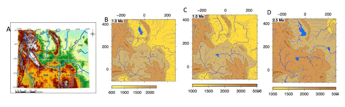
Figure 1. A) Modern landscape in the central Rockies and B-D) landscape modeling results for the late Miocene. Color bar represents elevation in meters. B) Model considers 500 m uplift in northeastern Wyoming and 200 m uplift in southwestern Wyoming, and climate parameters documented in literatures. Model explains the documented magnitude of erosion (800 m) in literature, and produces a drainage pattern similar to todays. C) Sensitivity test of model to uplift. This model causes 600 m of erosion in north-central Wyoming and 200 m in the rest of the state, but the drainage pattern is different from today's pattern. D) Model of erosion caused by climate change. This model considers topography, isostasy, and precipitation, a maximum of 30 m of erosion was achieved by matching the drainage pattern to modem drainage pattern.