Reports: UR851793-UR8: Fluid Evolution and Changes in Deformation Conditions During the Formation of the Central Appalachian Fold-and-Thrust Belt of Pennsylvania
 printer friendly
The analytical work has been divided into several tasks. One task involves examining the fluid inclusions and structural history of the Devonian shale sequence, including the Marcellus shale. Three students have worked, or are working on this task. Early results from this study were combined with work that Evans had done previously, and submitted as a manuscript to AAPG Bulletin with three students are co-authors. Results to date indicate a wide range of fluid inclusion trapping conditions across the Valley and Ridge province. Toward the hinterland, brine and CH4±CO2inclusions give paleo-overburden values above the Devonian shales of to 7-8 km. At the Appalachian structural Front, dominantly liquid petroleum inclusions give a much shallower 4 km paleo-overburden. Detailed fluid inclusion analysis of single quartz crystals shows that pore-fluid conditions changed from low pressure to high pressure during crystal growth and that it is reflected in the SEM-CL image of the crystal. Two students presented their poster presentations at NE GSA in March 2013. Evans and one student will be presenting their results in two posters at the Annual GSA meeting in October 2013. The third student is just starting his work in fall 2013. One of the students who worked on this task in 2012 is now in the Masters program at Bowling Green State University with full support.
Another task has been to construct a series of balanced cross sections around the central Pennsylvania salient. Evans is the primary on this task, but two students have also participated. One student in particular has constructed 3 line balanced cross sections across a portion of the southern Valley and Ridge province. He then digitized them into Midland Valley's 3D Move computer program and constructed a 3D model of the thrust system (Figure 2) that was presented at NE GSA in March 2013. This task is still in progress and the student is constructing 3 additional sections and refining his model (Figure 1). The results indicate that in Maryland, the Nittany anticlinorium is defined by a 17 km thrust duplication of a 2 km thick Cambrian-Ordovician carbonate sequence, with the upper plate thrusted into a duplex of four major horses for a total of 38% shortening. The westernmost horse has a fault-propagation-fold geometry forming the Wills Mountain anticline, whereas the other horses have a fault-bend fold geometry. To the north, the width of the anticlinorium decreases as the length of duplication of the carbonate sequence decreases. This corresponds to a structural discontinuity near the present location of the Potomac River. In southern Pennsylvania, the anticlinorium consists of two fault-propagation fold-style thrust sheets defining the Wills Mountain anticline on the west and the broad Friend's Cove anticline on the east. Structure has moderately overturned footwall synclines. The frontal limb of each thrust sheet is interpreted to be deformed into a series of imbricate thrust blocks forming triangle zones. Just south of the Latitude 40¡N tear fault, the structure continues as two thrust sheets with structural duplication with the underlying plate of less than 6 km. Increased displacement of the easternmost thrust results in the leading edge of the sheet being thrusted >3 km beyond its detached and faulted overturned limb. Forlandward of the Wills Mountain anticline, the carbonate sequence is thrusted into a fault-bend style fold as the Schellsburg dome. Total shortening for this section is 43%. Three regional cross sections across the entire fold belt have been completed (Figure 1), with a fourth in progress. These results will be presented by Evans at the annual meeting of the GSA in October 2013.
The third task involves a fluid inclusions and stable isotopic study of calcite veins in the Siluro-Devonian and Cambro-Ordovician carbonate sequences. Host rock and vein samples were collected from sites across the southern Valley and Ridge province. Thin sections were described, fluid inclusion microthermometry done, and oxygen and carbon stable isotopes data run at the Yale Earth System Center for Stable Isotopic Studies. The student working on this project presented his results at the NE GSA meeting in March 2013. He is continuing to work on the project in Fall 2013. Preliminary fluid inclusion data from the Tonoloway Fm. indicate fluid trapping at between 99° to 113°C. Fluid salinity is 19.5 to 23.7 wt. % equiv. Carbonate host rock δ18O values are between 21.6 and 24.5 ä V-SMOW and δ13C values are between -0.8 and 4.4 ä V-PDB. In general, vein isotopic values are slightly to significantly different form host rock values, indicating open fluid systems. However, other Tonoloway Fm. and Nittany Fm. sites have vein isotopic values that are similar to the host rock indicating closed fluid systems.
In the next year of the grant, we will continue to work on cross section construction, fluid inclusions microthermometry and stable isotope analyses.
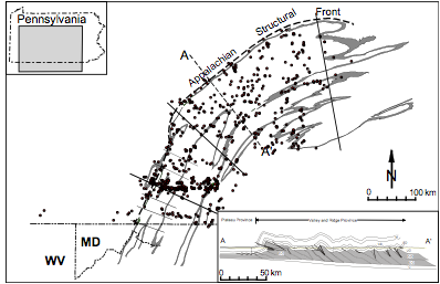
Figure 1. Location map
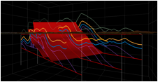
Figure 2 3D Model