Reports: ND850833-ND8: Predicting Channel Geometry in Faulted Hydrocarbon Reservoirs
 printer friendly
This project aims to understand the patterns of channels that initiate and evolve because of topographic changes imposed by fault displacement. Our primary field sites are located on the Volcanic Tableland of northern Owens Valley, in eastern California. Here, the evolution of a population of extensional (i.e. normal) faults has controlled the morphology and incision of a Late Pleistocene fluvial network. This offers a unique opportunity to link patterns of channel erosion and deposition to the fault patterns and processes. Because fault-related topographic changes are well understood here, we are able to link changes in channel morphology to specific patterns related to fault interaction and linkage by focusing on channels that flow in between en echelon (i.e. partially overlapping) faults. Increases in channel slope and decreases in the ratio width/depth indicate that displacement rate increases during interaction between overlapping fault segments. Moreover, our data show that these changes begin to occur during the very early stages of fault interaction, well before the fault geometry would indicate ongoing or imminent fault linkage. Channel slope and channel width and depth anomalies are not always coincident with one another; this indicates that they either erode through the fluvial systems at different rates or some threshold width/depth ratio must be reached before slope responds (Hopkins and Dawers, in revision). Additionally, this work implies that coupled landscape/tectonic models of rift margins likely underestimate fluvial incision rates and sediment supply due to changes in channel morphology driven by fault displacement rate acceleration.
Ongoing research is addressing changes in channel patterns and morphology along and across normal faults of different length scales. Initial results summarized above are largely for fault segments < 10 km long, where most channels drain areas between overlapping faults (Fig. 1a). Though this scale is appropriate for, say, the size of structures and channels within individual hydrocarbon fields, larger sediment supply systems are important for understanding the distribution of sedimentary deposits, including clastic reservoir units, in rift basins. Larger systems are more prone to captured drainages, as illustrated in Figure 1b. To address the scale issue, we are combining data from our California field site with data using digital topography for faults in Oregon and Idaho (the locale labeled Blue Dome on Fig. 2). Comparing catchment area to the area between the overlapping faults (also known as relay ramp area), we have identified a fault segment length-scale of ~10 km at which the drainage channel patterns change. This may ultimately be a useful predictive tool in predicting channel patterns in rift basin settings.
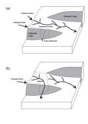
Fig. 1. Cartoon illustrating 2 normal fault segments, with drainage catchment and channel geometries.
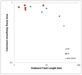
Fig. 2. Ratio of catchment area to area of fault overlap (relay ramp area), across a range of fault length scales.
Support from this project has had considerable impact on a PhD student, Michael Hopkins. Research related directly to the project constitutes at least two-thirds of Hopkins' evolving PhD dissertation. The funding has allowed him to gain field experience, attend a major national/international level professional meeting in order to give an oral presentation (Hopkins et al., 2012), and it has provided him with research to share at student-oriented venues sponsored by the petroleum industry (such as at the American Association of Petroleum Geologist's Student Expos). In addition, stipend support as a Research Assistant (RA) has allowed him to focus on research at a crucial timeframe in his tenure as a PhD student, rather than spend time working as a Teaching Assistant.
The impact of the research funding on the PI's career is two-fold. Firstly, it has allowed her to pursue an avenue of research that represents a new direction, in that the design of the project was to incorporate aspects of Earth surface processes (i.e., erosion, sediment transport and deposition), while placing them within the broader framework of her overall interests and expertise (in fault array evolution). Secondly, the project's student support has helped her fund a PhD student as an RA, thereby increasing her research group's overall productivity.