58th Annual Report on Research 2013 Under Sponsorship of the ACS Petroleum Research Fund
Reports: AC847377-AC8: Exhumation and Deformation due to Shallow Subduction above the Yakutat Microplate in Southern Alaska
Phillip A. Armstrong, California State University (Fullerton)
Subduction of the Yakutat microplate in southern Alaska, either directly or indirectly, has had a more profound effect on deformation in southern and central Alaska than any other geologic event in the late Tertiary. Subduction underplating and related tectonics are probably responsible for deformation leading to hydrocarbon traps in the Cook Inlet and perhaps in the North Slope area.
The Prince William Sound and western Chugach Mountains (PWS-CM) form an ~100x100 km syntaxial region. The PWS-CM syntaxial region lies ~20-30 km above the interface of the subducting Yakutat microplate and the North American plate and is located west of complicated strike-slip deformation in the St. Elias area. Our principal hypothesis for this work is that the PWS-CM syntaxial region is the location of rapid material removal by exhumation/erosion to balance out the accretionary flux brought in with shallow subduction of the Yakutat microplate. To test this hypothesis, we used low-temperature thermochronometry and field study of key areas of the Prince William Sound and western Chugach Mountains. We focused on the main syntaxial region and and the outboard region (toward the subduction zone) at Montague and Hinchinbrook Islands where we believe the effect of focused erosion might be the greatest.
Our work included five seasons of fieldwork to sample most of the critical areas of the PWS-CM region. Bedrock samples of granite, felsic dikes, and sandstone and glacial outwash samples from toes of tidewater and alpine glaciers were collected. Samples were collected via boat access in the fiords of the Prince William Sound, by helicopter in high elevation regions of PWS and critical new areas of the outboard Montague and Hinchinbrook Islands, and by jet boat for a critical transect up the Copper River. These samples are used to evaluate the exhumation history in a N-S- and plate-transport direction to test the hypothesis of focused regions of exhumation and make connections with other critical areas of deformation. Glacial outwash samples from toes of major glaciers draining the north and south sides (leeward and windward sides) were used to evaluate whether the mountains that are crossed by the glaciers contain different populations of ages – the glaciers essentially act as conveyor belts that sample much of the elevation range of the glaciated mountains.
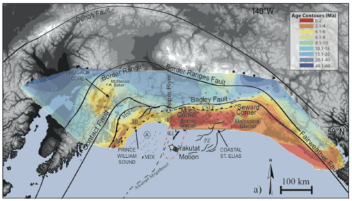
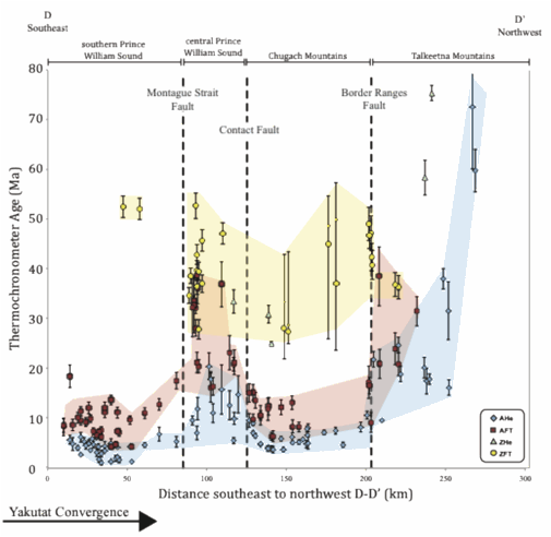
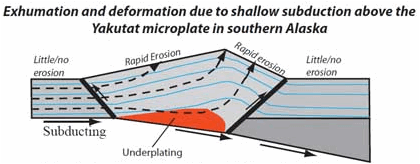
Bedrock (U-Th)/He ages from sea level are much younger than around the periphery of the syntaxial region. Single-grain ages as young as 2 Ma have been determined for the northern PWS and CM region. Overall, (U-Th)/He ages tend to decrease northward and into the syntaxis, with ages > 10 Ma in farther south. These results indicate that exhumation is focused in the syntaxial region. Apatite fission track ages show a similar trend, but with overall higher ages. Modern glacial outwash zircon fission-track ages from major glaciers give minimum age peaks of about 25 Ma on the north side of the western CM and 20 Ma on the south side. The youngest age peaks probably correspond to initial Yakutat exhumation, but overall the younger ages on south (windward) side indicate that higher magnitude and higher rate rock uplift has occurred there. In general, the age patterns indicate broad uplift of the western Chugach Mountains between major fault systems associated with underplating above the shallow-dipping megathrust. Our work in the western Chugach Mountains and the northern Prince William Sound region provides a much more complete picture of modes of rock deformation associated with shallow subduction. These modes can be characterized as: (1) collisional deformation in the southeastern (outboard region) areas where subduction of the buoyant Yakutat plate is deforming the toe of the overriding Southern Alaska Block via faulting and folding; (2) deformation 600 km north in the Alaska Range (inboard region) where multiple mechanisms related to Yakutat-driven strike-slip faulting, changes in crustal thickness, and changes in plate motion directions cause rock uplift of varying degrees; and (3) the PWS-CM area (in-between region) where uplift driven mostly by underplating.
Farther outboard at in PWS at Montague and Hinchinbrook Island, results indicate very rapid rock uplift and erosion with (U-Th)/He and fission-track ages as young as ~1 and 3 Ma, respectively, but with helium ages of >4 Ma elsewhere on Montague. These age regions are separated by major faults illustrating the intense partitioning of deformation in this outboard region. Montague Island is an area that underwent several meters of uplift during the 1964 M9.2 Alaska earthquake. Our interpretation for this area is that it is the western extension of extremely intense plate collision deformation documented in St Elias Mountains area to the southeast; this area of collision deformation is generally thought to turn south before getting to Montague area, but our new results it may continue west.
This work has helped fund research for two graduate students and eight undergraduates and has led to the publication of 19 abstracts and presentations at regional, national and international meetings. One major paper (Arkle et al., 2013) was published in GSA Bulletin and two papers currently are in review. This work has allowed the PI to: expand research efforts in new research directions; provided new opportunities in a new field area; collaborate with colleagues at the USGS and other institutions; and has expanded the capabilities of his lab. Importantly, this research has led to the completion of eight undergraduate theses and two Masters theses. Four of these students are now in Ph.D programs; the work on this project has been pivotal to each student's professional growth and has been a springboard into graduate programs across the country.
Figure 1. Map showing the apatite (U-Th)/He ages from this study (Chugach core and Prince William Sound areas) and other areas to the east. Note that AHe ages are relatively young in the Montague Island (MI) and Hinchinbrook Island (HI) and Chugach core regions.
Figure 2. N-S transect of low-temperature thermochronology ages from this study. The D-D' section extends NW from near the circled A in figure 1.
Figure 3. Schematic interpretation cross section for the Prince William Sound and western Chugach Mountains region.
Copyright © 2014 American Chemical Society


