Reports: ND856442-ND8: Discriminating Sediment Supply versus Accommodation Controls on Foreland Basin Stratigraphic Architecture in the Book Cliffs, Central Utah Using Detrital Double Dating
 printer friendly
From September 2016 to August 2017
Campanian Book Cliffs strata record the development of three eastward-prograding clastic succsions in the foreland basin east of the Sevier fold-thrust belt. There is an increase in progradation rate between the lower and middle succession, followed by a return to slower progradation rates in the uppermost succession.
In order to evaluate the controls on the rapid eastward progradation during the middle succession, this grant supported field work by the PI and two graduate students to Utah and New Mexico. During the field work, students measured stratigraphic sections and collected samples through critical middle–upper Campanian strata where previous research has observed anomalously rapid eastward progradation between 76 and 75 Ma. The strata measured are exposed in the Book Cliffs of Utah, near the towns of Price and Green River. They also measured and described, and collected samples from, equivalent stratigraphy exposed near the town of Farmington, NM.
The proposal supported laboratory analyses of the collected samples by one graduate student and one undergraduate. Students filled out our preliminary dataset consisting of U-Pb geochronology of zircon grains from Price and Tuscher canyons. The new, complete data set comes from six locations including Ferron, Rilda, Price, Horse, Tuscher, and Thompson canyons (Figure 1). The new dataset consists of more than 9,500 “accepted” ages (ages which pass our quality control measures) from 38 samples at the six locations (Figure 2 and 3).
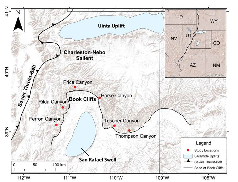
Figure 1. Locations of samples measured as part of this project to date.
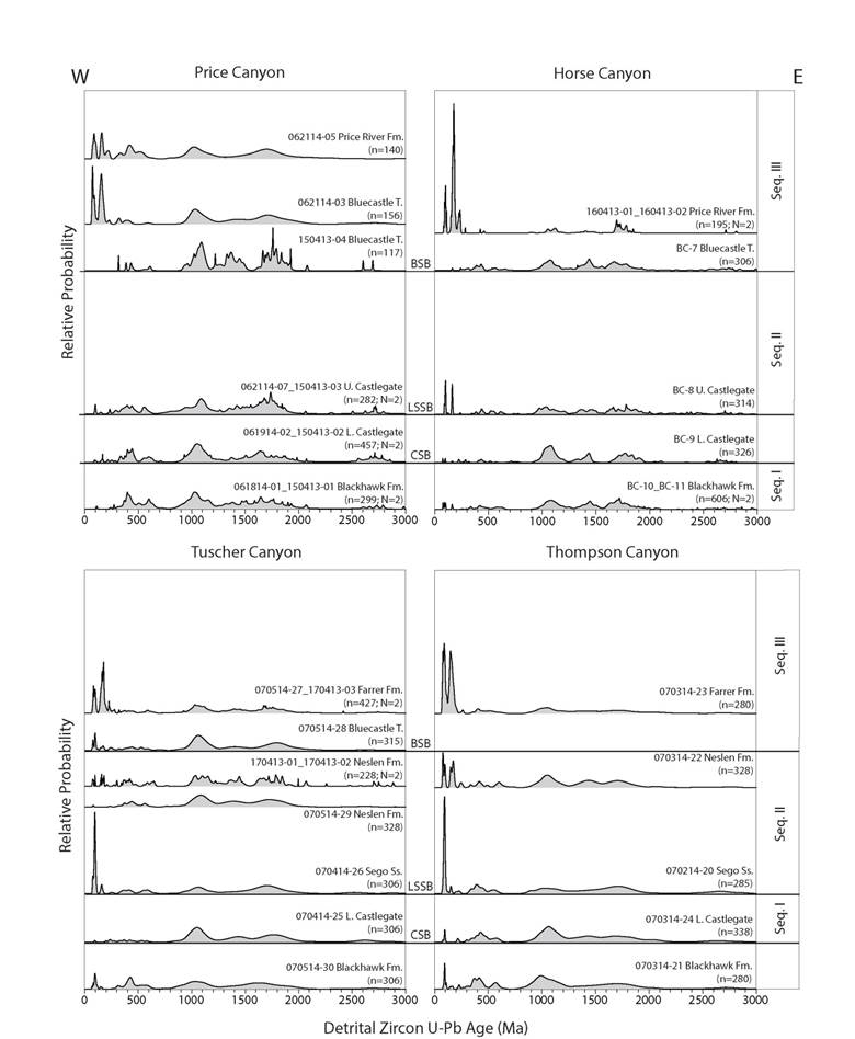
Figure 2. New zircon U-Pb geochronology from locations in a west-east transect (see locations in Figure 1). Samples are arranged in stratigraphic order, with oldest samples on the bottom and youngest samples on the top at each location. In this plot, individual zircon grain U-Pb ages and their uncertainties are represented as Gaussian curves. Those Gaussian curves are summed and normalized to produce the composite “probability density plots” displayed above.
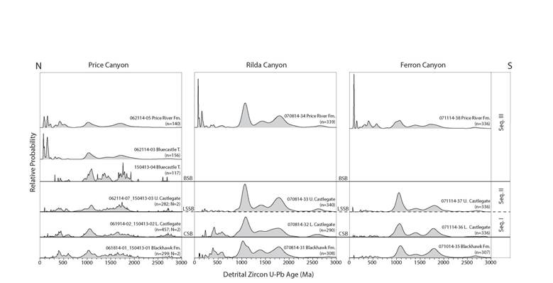
Figure 3. New zircon U-Pb geochronology from locations in a north-south transect (see locations in Figure 1). Samples are arranged in stratigraphic order, with oldest samples on the bottom and youngest samples on the top at each location.
In order to determine the sediment sources through time, we compare our new data to previously published detrital zircon U-Pb geochronology from potential sources (Figure 4).
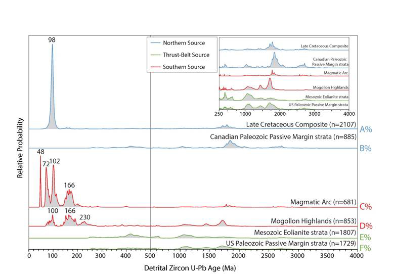
Figure 4. Potential sediment sources have characteristic distributions that allow us to discriminate source from to the north of the study area (blue lines above), west of the study area (green lines above), and south of the study area (red lines above). Data compiled from Laskowski et al. (2013) and May et al. (2013).
The new data confirm previous research and shed new light on sediment dispersal in and on the margins of the Late Cretaceous Western Interior Seaway. Results confirm previous interpretations that sediment from the Blackhawk Formation and Lower Castlegate Sandstone deposited between ~82 and 76 million years ago (Ma) was derived entirely from the thrust belt to the west of the study area (Figure 5A and B). This changes abruptly during deposition of the Sego Sandstone and Neslen Formation which were deposited between ~76 and 75 Ma. In these formations, we found the first evidence for significant mixing of sediment sources to the north and south of the study area, with the sediment that was derived from west of the study area (Figure 5C and D). Finally, between 75 and 73 Ma we found that input to the Bluecastle Tongue, and Price River and Farrer formations from sources to the north and west of the study area diminished and the study area was dominated by sediment derived from the south (Figure 5E and F). We conclude that the rapid progradation of sandstone observed from 76–75 Ma is the result of increase sediment input into the basin due to input and mixing from all three potential sources. In contrast, where one source dominates the basin (either the western source prior to 76 Ma or the southern source after 75 Ma), progradation is much slower.
. 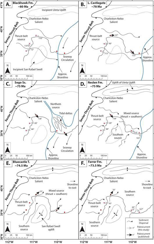
Figure 5. Paleogeographic reconstruction of the Campanian evolution of the Book Cliffs area, showing the interpreted sediment sources at six time slices.
As a result of this work, the PI was able to initiate a research partnership with colleagues at another state university. Data from this project was incorporated into a master’s degree at the partner university and will be included in a publication that will be produced from a second master’s thesis.