Reports: ND855903-ND8: Passive Seismic Investigations for the Formation Mechanisms of Intracratonic Basins
 printer friendly
New Madrid Seismic Zone and Illinois Basin crustal thickness and Vp/Vs ratio
Based on geological features and the characteristics of crustal thickness and Vp/Vs distributions, the study area (Figure 1) is divided into three sub-regions, including the Ozark Uplift, Mississippi Embayment (Reelfoot Rift and Rough Creek Graben), and Illinois Basin.
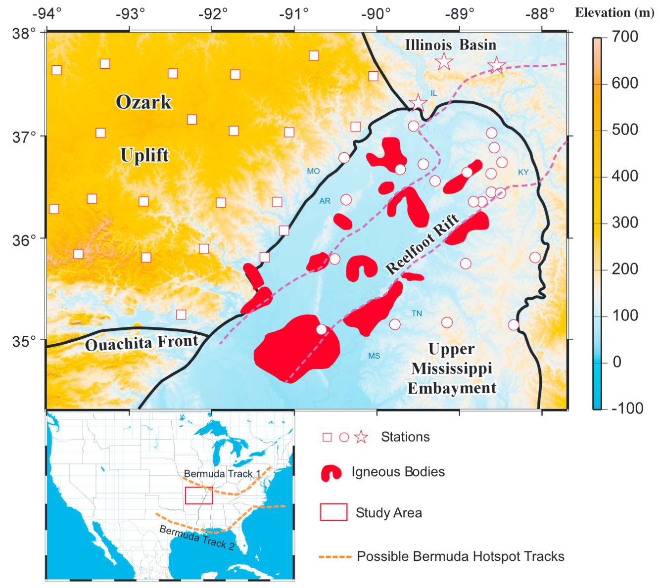
Figure 1. Topographic map showing major tectonic features (black lines), igneous bodies (red areas), and broadband seismic stations used in the study. Stations represented by squares, circles, and stars are located in the Ozark Uplift, UME, and the Illinois Basin, respectively. The area between the purple dashed lines is the Reelfoot Rift, in which the New Madrid Seismic Zone is located. The inset in the lower-left corner displays the map of the contiguous United States showing the location of study area (red rectangle) and proposed possible Bermuda hotspot tracks (orange dash lines).
The area experienced two phases of subsidence commencing in the Late Precambrian and Cretaceous, respectively. To provide new constraints on models proposed for the mechanisms responsible for the subsidence, we computed and stacked Vp/Vs receiver functions recorded by 49 USArray and other seismic stations located in the study area and modeled Bouguer gravity anomaly data.
Almost all the stations in the Upper Mississippi Embayment (UME) and many other stations are overlaid with unconsolidated Quaternary sediments, which lead to strong reverberations and a delayed first peak on the RFs. Because of serious reverberation, receiver functions in the sedimentary basin appear as mono-frequency signals. Strong near surface reverberations often mask converted phases from the Moto. A reverberation removal filter is applied to the receiver functions in order to pick Moho converted phases to be used to calculate crustal thickness, density, and Vp/Vs values.
All the three-component broadband seismic data utilized in the study are obtained from the Incorporated Research Institutions for Seismology (IRIS) Data Management Center (DMC). Data from magnitude 5 or greater earthquakes in the teleseismic distance (30 to 180 degrees) are requested and processed.
In the New Madrid Seismic Zone and Illinois Basin area, stacking of a total of 7627 radial receiver functions shows systematic spatial variations in crustal thickness and Vp/Vs ratio of the converted Moho phases among different geological provinces. The crustal thicknesses range from 26.8 to 50.3 km with a mean value of 38.4 km (Figure 2), and the resulting Vp/Vs observations of the 33 well defined stations range from 1.75 to 1.93 with an average of 1.83 (Figure 3).
The observed crustal thicknesses in the southern-most portion of the Illinois Basin range from 42.0 to 45.9 km, while the Vp/Vs values are from 1.78 to 1.81. The average crustal thickness is ~44.0 km, and the mean Vp/Vs value is ~1.80, which are comparable with those observed on the Ozark Uplift but is smaller than those obtained in the Mississippi Embayment.
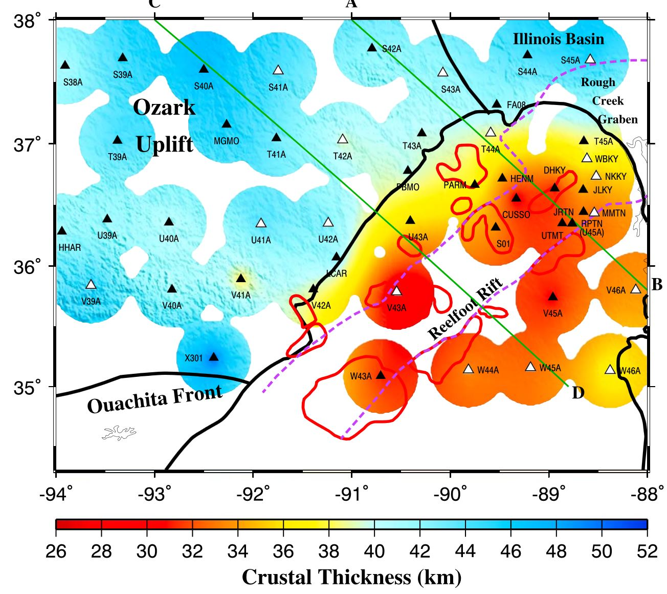
Figure 2. Resulting thickness of the crustal layer corresponding to the maximum stacking amplitude. Filled triangles are the stations with excellent quality RF measurements, and open triangles are the ones with good quality. To produce the plot, the observations are fitted using a surface gridding algorithm. Only areas that are 40 km or closer to a station are shown. Lines A-B and C-D are the locations of the gravity model shown in Figures 4 and 5, respectively.
Our study suggests that the UME is characterized by a mafic and high-density upper crustal layer of 30 km thickness, which is underlain by a higher-density lower crustal layer of up to 15 km. Those measurements, in the background of previously published geological observations on the subsidence and uplift history of the UME, are in agreement with the model that the Cretaceous subsidence, which was suggested to be preceded by an approximately 2 km uplift, was the consequence of the passage of a previously proposed thermal plume. The thermoelastic effects of the plume would have induced wide-spread intrusion of mafic mantle material into the weak UME crust fractured by Precambrian rifting and increased its density, resulting in renewed subsidence after the thermal source was removed.
In contrast, the Ozark Uplift has crustal density, thickness, and Vp/Vs measurements that are comparable to those observed on cratonic areas, suggesting an overall normal crust without significant modification by the proposed plume, probably owing to the relatively strong and thick lithosphere.
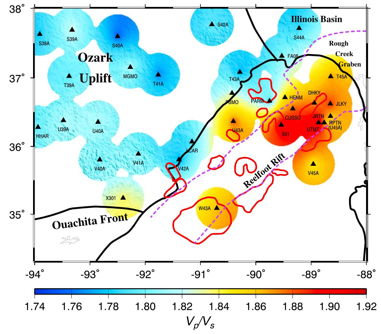
Figure 3. Resulting Vp/Vs measurements obtained at the stations with excellent quality RF measurements.
The resulting Bouguer gravity anomaly models along profile A-B and C-D (Figures 4 and 5) are consistent with the existence of both a high-density upper crustal layer and a higher-density lower crustal layer beneath the UME. The Reelfoot Rift is characterized by an upper crustal graben and an altered lower crustal layer, and the existence of the high-density upper crustal layer is consistent with the distribution of the relatively high Vp/Vs values (Figure 3).
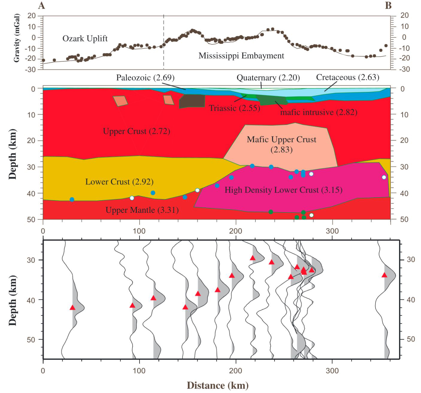
Figure 4. Gravity model of the crust and upper-most mantle and stacked receiver functions along profile A-B (Figure 3). Densities are in g/cm3. (top) Observed (black dots) and calculated (solid line) Bouguer gravity anomalies. (middle) Resulting gravity model. Blue circles represent the depth of the arrival on the thickness-Vp/Vs plots with the largest stacking amplitude at stations in a 100 km wide band centered on the profile (filled circles are the stations with excellent RF measurements, and open circles are the stations with good RF measurements, and green circles are the approximate depths of the deeper secondary arrival. (bottom) Stacked and depth-converted RFs using the resulting Vp/Vs corresponding to the maximum stacking amplitude on the thickness-Vp/Vs plot for each of the stations.
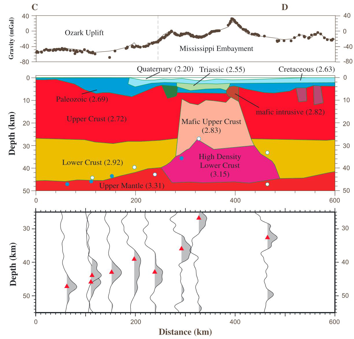
Figure 5. Same as Figure 4 but along profile C-D.
Preliminary results in the Michigan Basin
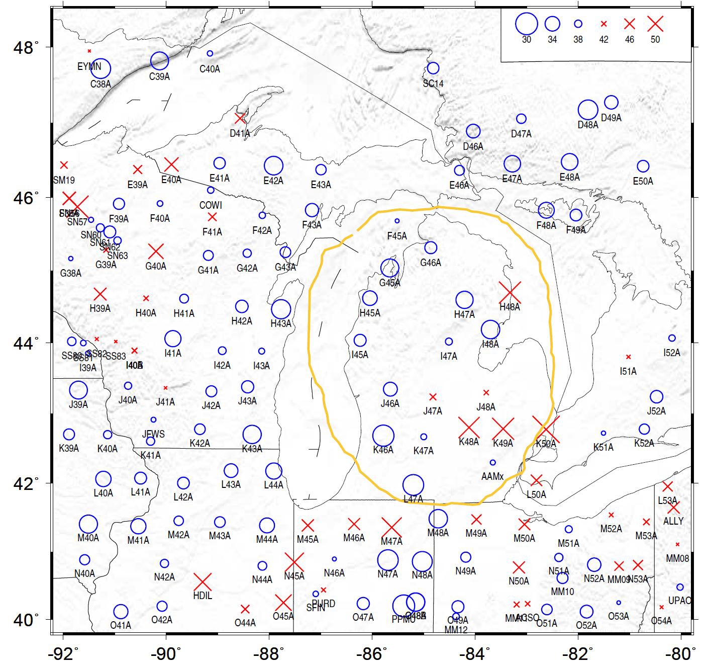
Figure 6. Resulting crustal thickness.
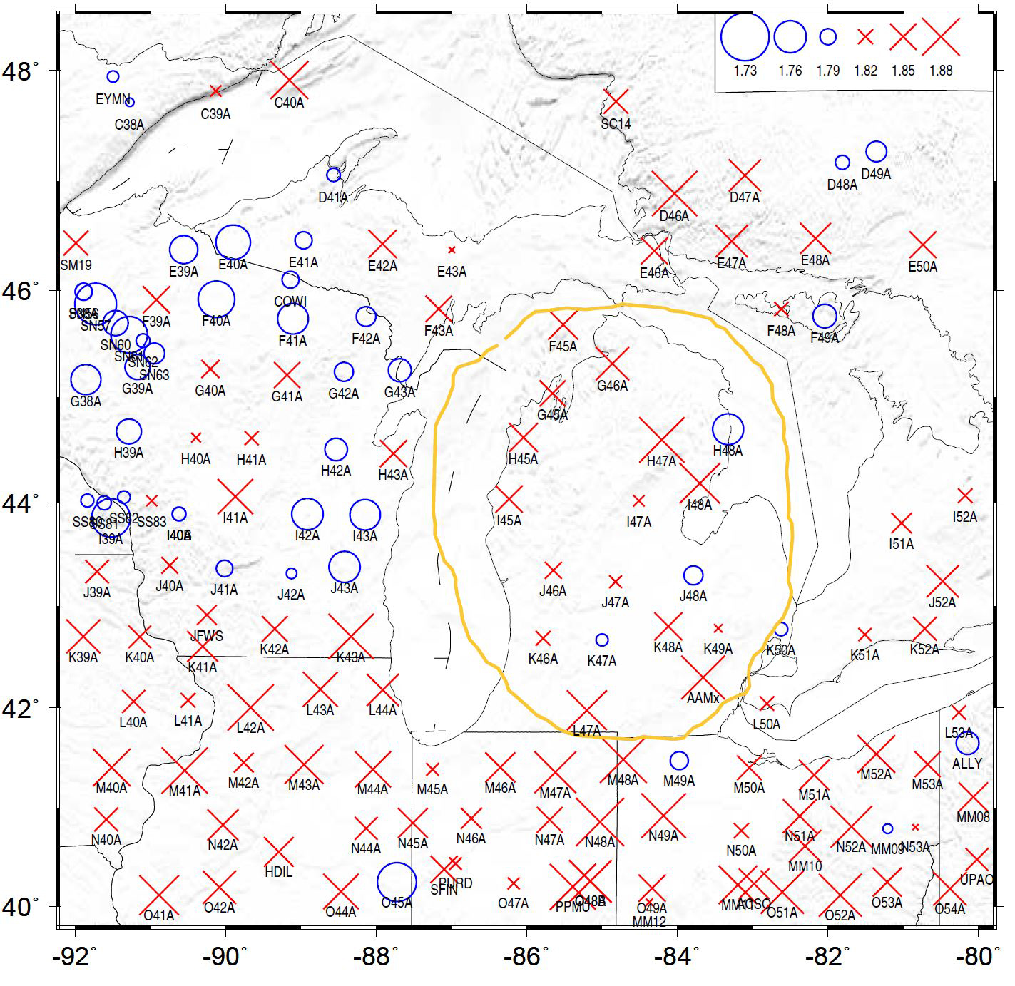
Figure 7. Resulting Vp/Vs values.
v Career impact
The studying of the formation mechanisms of intracratonic basins is a new research direction for PI and the students involved. The studies have significantly broadened the team’s overall research directions. We plan to investigate more basins not only in the North America but also other areas in the world.