Reports: ND856755-ND8: Details of Ancient Fluvial Systems: Capturing 3-D Architecture and Testing Depositional Models with UAVs, Photogrammetry, and Fieldwork
 printer friendly
Outcrops of sedimentary strata are critical for understanding and predicting reservoir architecture in the subsurface. This is particularly true for fluvial sandstone reservoirs, which vary over multiple scales and in 3D space. In this study we have focused on utilizing emerging technologies and traditional fieldwork to create improved stratigraphic models of fluvial deposits and provide new workflows for collecting 3D outcrop data.
Our methods for obtaining 3D outcrop reconstructions combine camera-mounted unmanned aerial vehicles (UAVs) with Structure-from-Motion (SfM) photogrammetry. UAVs allow us to collect thousands of high-resolution digital images of stratigraphic exposures over extensive areas. These images are processed using SfM photogrammetry, which is a relatively new technique that uses multiple overlapping images of the same object combined with image-based extraction algorithms to reconstruct the location of individual points in a 3D reference frame (Fig. 1). This procedure produces geolocated 3D point clouds, digital surface models, orthomosaics, and photorealistic outcrop reconstructions at centimeter-scale resolution. We have tested this method in control locations with ground-based measurements and established a relative and absolute accuracy for this technique.
We have collected initial data from fluvial sandstone outcrops of the Salt Wash Member of the Morrison Formation (Jurassic) in central Utah. In particular, we have examined an area near Green River, Utah, where fluvial sandstones of the Salt Wash Member are exposed in both vertical and plan-view outcrops (Fig. 1). The Salt Wash Member was deposited as part of a distributive fluvial system (DFS) that emanated from ancient highlands located to the southwest of present-day Utah. DFS depositional models are relatively new; therefore, our high-resolution 3D data set will serve as the basis for a refined model of fluvial architecture within these deposits.
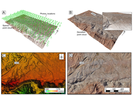
Figure 1. A) An oblique perspective image of the sparse point cloud created from SfM. Green circles and rectangles above the point cloud represent the locations of the photos collected by the UAV as it flew above the study area. The same road is denoted in each figure to help with orientation. B) Densified point cloud, same perspective as in (A). Inset shows a smaller scale subset of the densified point cloud. C) Vertical perspective of the digital surface model created from the images and SfM processing. Vertical scale is displayed in meters above sea level. D) Orthomosaic of the study area, vertical perspective.
Initial efforts have focused on establishing the relative and absolute accuracy of the SfM technique and examining one particular portion of the Salt Wash Member outcrop. The relative, or internal accuracy of the SfM reconstructions is at the centimeter scale, whereas in absolute space the SfM technique had an average horizontal and vertical offset of less than 2 m. We examined a 1x1 km area of the Salt Wash Member in Utah, collecting over 500 digital images from the UAV as it flew 90 m above the ground surface. The resulting point cloud, orthomosaic, and digital surface model had a resolution of 2.7 cm/pixel and provide clear images of features that could not be observed from the ground. Within the sandstone body several distinct architectural elements are identifiable and mappable in the orthomosaic and digital surface model (Fig. 2). A series of east-west trending curvilinear sandstone bodies and surfaces are present in the central portion of the exposure, which based on their orientation and related paleocurrent data are interpreted as lateral accretion sets. We interpret this sandstone body as an exhumed point bar deposited by an east-northeast flowing meandering river.
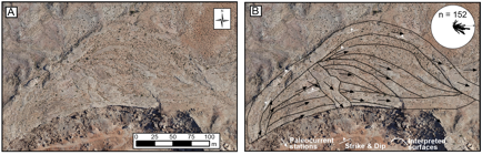
Figure 2. A) Orthomosaic of the sandstone body exposed in the study area. B) Data from the sandstone body, derived from both UAV-SfM imagery and ground-based observations. Interpretations were combined with paleocurrent data taken at multiple stations. Arrows show the average for each station. Orientations of surfaces and sandstones are also shown.
Preliminary results from this project are encouraging and suggest critical insights can be gained from these and other outcrop exposures. Thus far, two masters students and one undergraduate have been supported as part of this project. Portions of this work have been published in a peer-reviewed journal and presented at several international geoscientific conferences.