Reports: DNI853544-DNI8: Testing Models of Dune Field Pattern Formation in Ancient Aeolian Stratigraphic Successions - Permian Cedar Mesa Sandstone, Utah and Jurassic Norphlet Sandstone, Gulf of Mexico

Ryan Ewing, PhD, Texas A&M University

Project year 1 involved gathering a team and ramping up toward developing an aeolian stratigraphic model that incorporates spatial heterogeneities related to the self-organization of wind-blown dune fields.  Maria Gutierrez was the first member to join the team. She is a Master’s degree candidate from Venezuela and the lead for the Norphlet Sandstone component of the work. John Phillips is an undergraduate and the lead on developing terrestrial lidar (t-lidar) methods for collecting field data in Utah.  We had a number of researchers join in on a field expedition to White Sands Dune Field, New Mexico where we collected land seismic and ground-penetrating radar (GPR) in the dune field.

Norphlet Sandstone. The Norphlet Sandstone is an aeolian oil and gas reservoir in the Gulf of Mexico and an opportunity to develop and test our model with subsurface data. Master’s student Maria began in January of 2014 and has been gathering background data for the Norphlet Sandstone Project. She collected a GIS database of Gulf of Mexico maps fr om previous work and identified the relevant core that needed to be measured and sampled at the Alabama Geological Survey. She coordinated with the core laboratory in Alabama to 
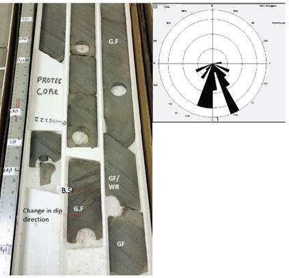
measure core for 1 week during July. During this time she measured ~ 700 ft of core in two locations and gathered geophysical logs for the cores (Fig. 1). She will return this year to complete measuring other core samples. She has thin sections from these cores and will be performing grain size and shape analysis of the primary aeolian grains to be used in environmental reconstruction.  These data will be used in conjunction with the Cedar Mesa Sandstone data as those data come online in the coming year.

Figure 1: Photograph of section of Mobile Field Well core showing the Norphlet Sandstone and rose diagram showing dip directions taken from dip meter logs. The photograph is labeled with different stratification types – G.F. grainflow, W.R. wind ripple and B.S. 1st order bounding surface.

Cedar Mesa Sandstone: The Cedar Mesa Sandstone, exposed in central Utah near Canyonlands National Park, provides the key exposures for our outcrop analysis. Undergraduate John is taking the lead on learning our Leica ScanStation t-lidar and RTK GPS, which will be a primary field tools. He has tested the equipment around campus and in the laboratory and is ready for our field campaign in October of 2014. We will spend several days gathering preliminary data to refine our data analysis methods. We are looking for a MS or PhD to join the team next year and take over as John moves off to graduate school.  We are planning several weeks in the field summer to gather more t-lidar data and samples.   

White Sands Dune Field:  White Sands is the key modern analog for the project’s overarching research goals. Our White Sands Dune Field expedition emerged as a collaborative effort with geophysicist Bobby Reece at Texas A&M and geomorphologist Amanda Keen-Zebert at the Desert Research Institute. Graduate student, Will Middlebrook, joined the group to help with the data collection.  The aim of our expedition was to collect geophysical data on the architecture of modern aeolian stratigraphy at two spatial scales. At the fine-scale, we gathered GPR data of protodunes and dune collisions to better understand the stratigraphy associated with these elements of dune self-organization (Fig 2.).

Figure 2: Ground Penetrating Radar data showing the topography and internal stratigraphy of a protodune at White Sands Dune Field, New Mexico. Inclined surfaces are interpreted as forests and bounding surface representing the migration of the protodune in response to different wind regimes at White Sands Dune Field.

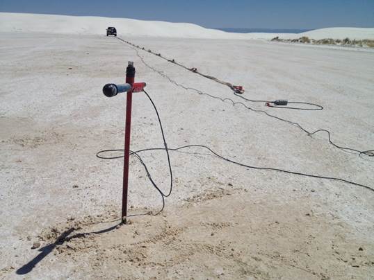
At a coarser-scale, we gathered land seismic at two locations within the dune field to identify basin-scale controls, such as paleoshorelines or faults, on the accumulation of the dune 
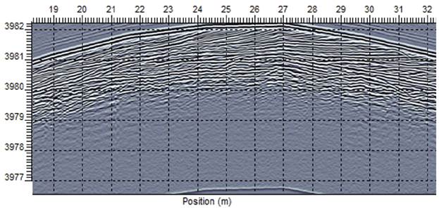
field (Fig 1b). Initial results from the GPR data show highly resolved centimeter-scale stratigraphy of protodunes that indicates these bedforms adjust to semi-annual wind patterns and generate low-angle bounding surfaces that represent a shift in the seasonal winds (Fig. 1a). We will look for this stratigraphy in Utah during our fall and summer 
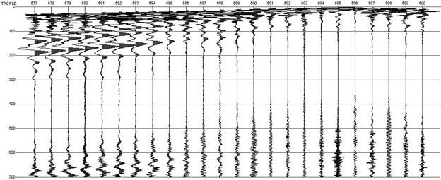
field campaigns. More processing is underway on the seismic, but initial thoughts are that paleolake clay layer is visible in the seismic and marks the beginning of sand accumulation (Fig. 3).


Figure 3: (a) top: Photograph of geophones and source at White Sands Dune Field, New Mexico. (b) bottom: Unprocessed seismic data from the central part of White Sands Dune Field. Visible reflections down to 300ms in 2-way travel time. Left axis is time (ms), top axis is meters.

Additional processing, analysis and interpretation is underway for both datasets and results will be presented at AGU December 2014 by Texas A&M Geophysics Undergraduate Patrick Wagner, Professor Bobby Reece and the PI.

Professional Development:  Project year 1 allotted a number of opportunities for training and advancement.  The research efforts have broadened the PI’s portfolio by focusing on the detailed stratigraphic elements of aeolian systems. Additionally, the PI has added a number of geophysical methods to his field portfolio for modern and ancient sedimentary systems.  He was invited to present the ideas put forth in the DNI proposal at the SEPM Augtogenic Dynamics of Sedimentary System’s conference and co-lead a field trip to discuss aeolian units in Colorado. Master’s student Maria has gained valuable experience gathering and organizing difficult to access well data and is learning how to analyze aeolian stratigraphy in drill core and through geophysical logs.  Additionally, she is developing her communication skill set with a poster presentation of her research at the Berg-Hughes Center Symposium at Texas A&M in Sept. 2014. Undergraduate John Phillips has become an expert with modern field data collection techniques using RTK-GPS and t-LiDAR. He is readied for a field campaign to Utah in October of 2014.  John will develop a poster presentation for our departmental undergraduate research forum.