AmericanChemicalSociety.com
Reports: B8 47887-B8: Development of a Young Pull-Apart Basin in the California Continental Borderland: High-resolution Seismic Reflection Profiling of San Pedro Basin
The purpose of this project is to unravel the tectonic history and evolution of San Pedro Basin. Such a study must consider two prominent pop-up structures flanking the basin, Palos Verdes Peninsula and Santa Catalina Island. A significant grid of seismic reflection data, from USGS and elsewhere, already exists in the northeastern portion of the basin adjoining Palos Verdes, but similar coverage did not exist prior to this study in the southwestern part or near the island. Accordingly, data collection in this study concentrated in the southwestern area, especially in the last year (2009), when a grid of data was collected on the Catalina shelf.
Since the last report to PRF (Oct. 2009, after the 2009 data were collected but before they were processed), three datasets were added to the project and interpreted: 1) processed 2009 seismic reflection data (Figure 1), 2) old seismic data in the southern San Pedro Basin, including paper records that recently became available and were converted to digital form (Figure 1), and 3) high resolution (1 to 10 m) multibeam bathymetry images collected by California State University Monterey Bay (CSUMB; Southern California Seafloor Mapping Program) that cover the entire Catalina shelf (Figure 2). The following results are based on these and previously available data:
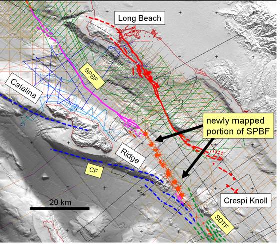
Figure 1. Seismic lines (2009 lines are light blue, 2008 dark blue, old paper records black, other digital data green and orange). SPBF purple except the newly mapped part in red.
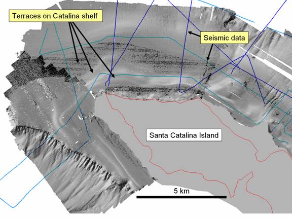
Figure 2. CSUMB multibeam bathymetry showing seafloor benches. This is a portion of the dataset, which entirely surrounds the island.
The San Pedro Basin fault (SPBF) appears to be a continuous fault across San Pedro Basin to near Crespi Knoll to the south, where it joins with the San Diego Trough fault (SDTF). This is based on seismic and bathymetry images in the southern part of the basin, where the fault was poorly mapped, if at all, in the past (Figure 1). This means that the SPBF and SDTF together form a more or less straight fault system some 300 km in length (Figure 3), a major active structural feature of the California Continental Borderland, and a potentially significant seismic and tsunami hazard (Figure 4). This finding in itself could lead to reconsideration of some concepts of Borderland structural evolution.
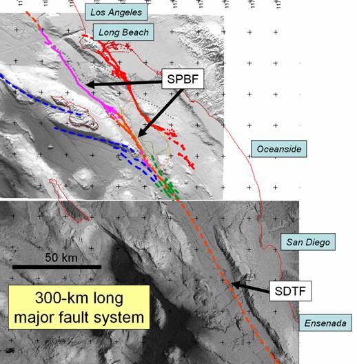
Figure 3. SPBF-SDTF system. CF is blue.
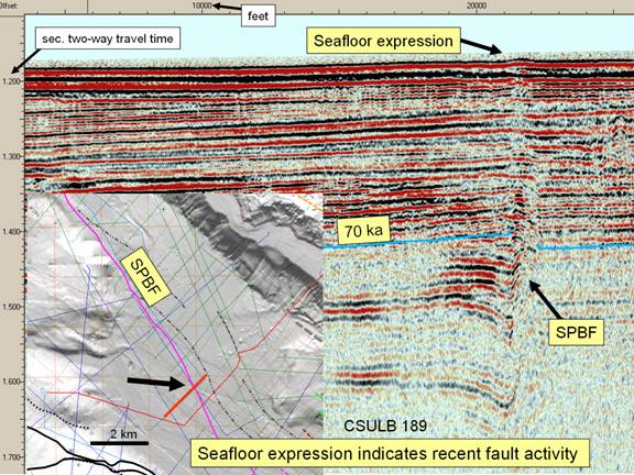
Figure 4. Active SPBF (seismic acquired by this project in 2008).
Bathymetric imaging (CSUMB) reveals a series of terraces or benches on the Catalina shelf (Figure 2). Some of these are 400 m below sealevel, approximately twice the sealevel range possible with glaciations. Seismic images indicate that these benches are depositional, possibly deltaic. Well-defined marine terraces are lacking on Santa Catalina Island, in contrast to Palos Verdes with its series of up to thirteen terraces. Dating of terraces, and of marine sediments along the offshore Palos Verdes fault indicates that Palos Verdes peninsula and a surrounding tectonic block along the northeast margin of San Pedro Basin has been uplifting at least 400 m over the last 600,000 years (600 ka; Francis and Legg, 2007). Unpublished reports of poorly-defined, eroded (possibly older) terrace deposits on the island, together with the submarine benches, suggests that Catalina has been subsiding during much of the time Palos Verdes has been uplifting.
In seeming contrast to the above results, Santa Catalina Island has been shown to be an uplift feature (White et al., 2004). However, this uplift may belong to an earlier period than that represented by the seafloor benches. Catalina Ridge, a 100-km feature including the island (Figure 1), and adjacent San Pedro Basin, with 4-5 km of structural relief between them, are associated with the SPBF-SDTF fault system, and another related fault, the Catalina fault (CF). Motion along the SDTF-CF would result in a restraining bend and associated pop-up along the more westerly CF trend. This, according to White et al. (2004), would be responsible for the uplift of the island and the entire Catalina Ridge relative to San Pedro Basin. In San Pedro Basin, seismic images reveal two major sediment sequences; the lower one is tilted, dips away from Catalina Ridge, and onlaps onto the basement of the ridge. In contrast, the upper sequence is mostly flat and onlaps onto the lower sequence (Figure 5). Correlation to dated sediments in Santa Monica Basin indicates that the upper sequence sediments range in age from 0 to up to 600 ka. Therefore the upper sequence was deposited while Palos Verdes was uplifting, but its lack of onlap onto Catalina Ridge means that the Ridge slowed or stopped uplifting before the upper sequence was deposited.
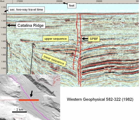
Figure 5. Seismic line across San Pedro Basin showing the SPBF and sediment sequences.
The restraining bend uplift associated with the CF was active while the San Pedro Basin lower sequence was deposited, as indicated by the dip and onlap of the latter. Eroded terraces on the island, if they exist, would have formed during this time. Sometime between approximately 200 and 600 ka, this activity slowed down and possibly stopped. This could have happened if the motion along the CF transferred to the SPBF, meaning that the SPBF cut through and formed a fault system with the SDTF. The relatively flat upper sequence and the benches on Catalina shelf would both date to a subsequent time when relative subsidence occurred.
This change in kinematics of the SPBF-SDTF-CF system is a major event in the history of San Pedro Basin. Clearly fault motions are a determining factor in depositional patterns in the basin. Changes such as this are probably widespread in the Borderland, with its shifting plate vectors associated with plate boundary evolution, leading to the need for four-dimensional analysis. San Pedro Basin cannot be regarded as a classic pull apart as it owes its morphology to a multi-stage dynamic history, but it appears to have some pull-apart characteristics.
An abstract has been accepted for presentation at the American Geophysical Union (AGU) meeting, December, 2010, and a full paper is in preparation.
