AmericanChemicalSociety.com
Reports: AC8 46170-AC8: Absheron Allochthon: Evidence for South Caspian Seafloor Deformation in Response to Climatically Driven Hydrate Dissociation
A large (>2,500 km2) late-Pleistocene zone of seafloor deformation and slumping, called the Absheron Allochthon (AA), has been imaged in the South Caspian Basin (SCB) using 2D (Diaconescu et al., 2000, 2001, 2002) and 3D seismic datasets. Since the history of sea level changes in the Caspian Sea in the past ~700 ka emphasizes a major ~100 m rise (Khvalyn transgression) and ~100 m drop (Yenotavian regression) in sea level during the late Pleistocene which would cause the expansion and subsequent dissociation of a massive gas hydrate reservoir, the emplacement of the AA may be related to the dissociation of gas hydrates (Kroonenberg et al., 1997; Mamedov, 1997). Such a sea level rise would increase seafloor pressure over a larger portion of the SCB, allowing gas hydrates to form further inland within the marine sediments. A ~100 m sea level drop following this hydrate reservoir expansion would result in a ~1 MPa pressure reduction on the seafloor, and due to the quasi-stable nature of gas hydrates this drop in pressure could provide a mechanism for gas hydrate dissociation. This research utilizes 2D and 3D seismic data in conjunction with well data to place temporal constraints on the emplacement of the AA to evaluate whether this large-scale submarine slump could be related to the dissociation of gas hydrates. These data are uniquely set to evaluate proposed mechanisms for late-Pleistocene large-scale submarine slope failure, and favor a relationship with the dissociation of underlying gas hydrates.
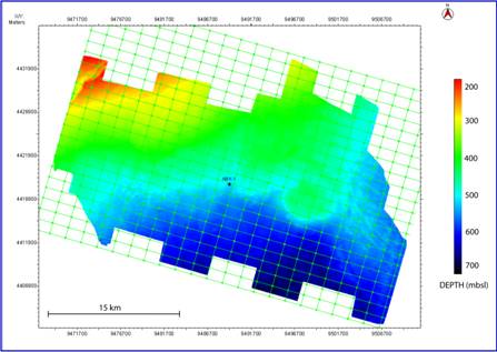
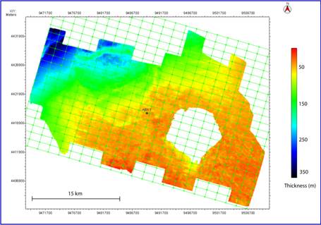
The seafloor within the study area dips to the Southeast (Fig. 1) and ranges from ~186 720 meters below sea level (mbsl). Following this trend, the uppermost sedimentary package (classified as all sediments overlying the AA) is thickest in the northwestern portion of the survey (> 350 m) and thinnest in the southeastern portion of the survey (< 50 m). An isopach map of the uppermost sedimentary package can be seen in figure 2. A general ENE WSW trend can be observed on this isopach map separating a thicker sedimentary package to the NW displaying a higher-angle SE dip from a thinner sedimentary package to the SE which maintains a relatively constant thickness and is generally sub-horizontal. Seismic reflections within this package are relatively continuous, and no major faulting is observed.
Figure 1. Seafloor bathymetry. Note the circular
expression of the mud volcano in the central-eastern portion of the survey.
Figure 2. Isopach map of the uppermost Quaternary
sedimentary package overlying the Absheron Allochthon.
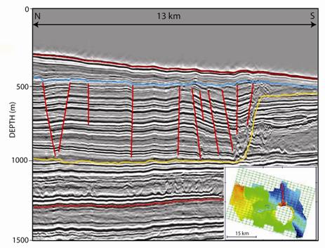
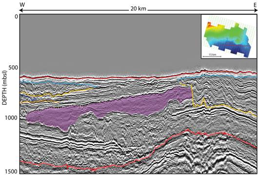
Figure 3. North to South seismic profile showing the
extensional and compressional features observed within the continuous facies
component of the AA. HORIZONS (top to bottom): seafloor (red), top of AA
(blue), base of AA (yellow), Absheron series (red). Faults are shown in red.
Note the extensional features within the northern portion of the profile and
the compressional features in close proximity to the northern buttress of the
mud volcano where a sharp topography change is observed on the base of the AA.
Seismic profile location shown atop a depth map of the base of the AA.
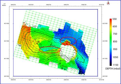
Figure 4. Depth map of the base of the AA superimposed
with contours of the Absheron series horizon. Note the WNW ESE axial trend of
the deeper dome structure represented by contours. Areas of compression within
the AA are circled in red.
A zone that is bounded by a positive-polarity reflection at the
top and a high-amplitude negative-polarity reflection at the base can be
observed within the 3D seismic survey south of the mud volcano (Fig. 5). A loss
of reflection amplitude is observed throughout the majority of the zone,
however minor stratigraphic features can be seen. In addition, sporadic
high-amplitude positive-polarity reflections are observed separating segments
of the zone, making 3D mapping difficult. The base of the zone is highly
irregular in some areas, containing small diapir structures. The zone does not
appear to be laterally continuous throughout the rest of the dataset, and
truncates against adjacent deformed sediment.
Transport direction of the AA still needs to be assessed based on
geometric and textural differences with surrounding relatively undisturbed
strata. Reflections within the faulted continuous facies of the AA do appear to
correlate with surrounding strata, suggesting that transport distance may be
minimal. Horizontal shortening along the ramp separating the continuous facies
component and the transitional zone is estimated at ~375 m based on reflector
geometry, and shortening throughout the remainder of the AA appears to be
minimal. An average sedimentation rate of 1.43 m/kyr was used to calculate an
age of 91 ka for the youngest sediments directly underlying the AA. It is
important to note that this age corresponds to the youngest sediments directly
underlying the AA, and does not take into account the time required for the
deposition of sediments contained within the AA. Therefore, the previously
reported age of 35 42 ka is closer to the emplacement time of the AA.
Figure 5. Low-amplitude zone observed South of the mud
volcano. Note the irregularity to the base of the zone and the sharp truncation
against the adjacent AA bounded by blue (top) and yellow (bottom) horizons.
References Diaconescu, C. C., and J. H. Knapp. 2000. Buried Gas Hydrates in
the Deepwater of the South Caspian Sea, Azerbaijan: Implications for
Geo-Hazards. Energy Exploration and Exploitation, 18 (4): 385-4000.
Diaconescu, C. C., R. M. Kieckhefer, J. H. Knapp. 2001.
Geophysical evidence for gas hydrates in the deep water of the South Caspian
Basin, Azerbaijan. Marine and Petroleum Geology, 18: 209-221.
Diaconescu, C. C., and J. H. Knapp. 2002. Gas Hydrates of the
South Caspian Sea, Azerbaijan: Drilling Hazards and Sea Floor Destabilizers.
Paper presented at the 2002 Offshore Technology Conference, May 6-9, in
Houston, Texas.
Kroonenberg, S. B., G. V. Rusakov, A. A. Svitoch. 1997. The
wandering of the Volga delta: a response to rapid Caspian sea-level change.
Sedimentary Geology, 107: 189-209.
Mamedov, A. V. 1997. The Late Pleistocene-Holocene history of the
Caspian Sea. Quaternary International, 41: 161-166.