44868-GB8
Controls on the Development of Mixed Siliciclastic/Carbonate Under-Filled Incised Valleys: Lessons from the Late Pleistocene/Holocene History of Baffin Bay, Texas
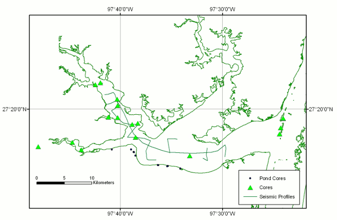
During the past year we have collected a total of 16 cores and 3 elevation profiles (Fig. 1). The longest of these cores was 8.8 m long. 6 of these cores and the elevation profiles came from small ponds just to the south of Baffin Bay. All but two of these cores have been cut and described to date. We have obtained 6 new radiocarbon dates (for a total of 22) from the cores from the Baffin Bay area.
Adding upon work from last year, which largely delineated the shape of the Baffin Bay incised valley and the major flooding surfaces within it, the new cores have allowed a better understanding of the type of fill found within the incised valley. The Baffin Bay incised valley contains three depositional elements unique to its system in comparison with other Texas incised valleys. These three unique systems include: mud flats, serpulid worm-tube reefs, and shelly spits. These unique systems did not form until sometime after the first flooding event at 8.0 ka and most likely after the second at around 5.5 ka. Prior to 8.0 ka the architecture of the incised valley was similar to that of the other Texas incised valleys, with a bayhead delta, open-bay, and most likely lower-bay fill.
The mud flats of Baffin Bay occur in the upper reaches of the bay. The mud flats occupy what in other incised valley systems are bayhead deltas. They are large, covering several 10's of km2 and are covered by algal mats. A core taken in one of these mud flats contains over 2 m of alternating sandy silt and sandy lamina/beds with an abundance of algal mats, small carbonate nodules, and organic material. Compared to other depositional elements in the bay it contains little shell material. The worm tube reefs are very common within Baffin Bay and produce local highs that breach the water surface during low tides. 3 cores taken as a transect away from one of these reefs reveal mostly sandy and shelly beds emanating away from the hard structure. The hard structure itself is composed of worm tubes all oriented in an upward direction. The structures hindered the completion of 2 attempts to take long cores within the lower parts of Baffin Bay (e.g., we could not core through them). The third feature unique to Baffin Bay is the presence of internal spits composed of almost exclusively shell hash. They are manifested as clinoforms in seismic profiles and sandy shell hash in cores.
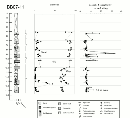
We also measured the magnetic susceptibility of sediments on a very fine (~5 cm) interval within the longest core taken in Baffin Bay. The record of magnetic susceptibility shows several spikes (Fig. 2). Most of them are associated with carbonate nodules within the sediment, but one spike is not associated with carbonate nodules. This spike is located at the same depth as a spike measured from an older core taken in neighboring Corpus Christi Bay that dates to the 8.2 ka climatic event. Our hypothesis is that this magnetic susceptibility spike can be used as a correlation tool within the bays of the Gulf Coast. We plan on 14C dating of the Baffin Bay core magnetic susceptibility spike to solidify the correlation.
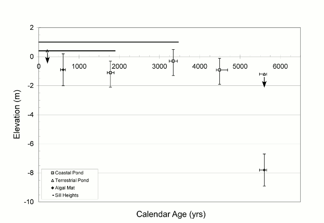
In addition to the cores within Baffin Bay proper, we utilized field-time in which weather conditions did not allow coring on the water to take 4 more vibracores from 2 additional shallow ponds on the fringes of Baffin Bay (Fig. 1). The 4 additional cores confirm the interpretations from last year of 6 major facies within these ponds and their evolutionary model. Additional radiocarbon dates where obtained from cores taken last year and place constraints on the sea-level history over the last 5 ky within the region. The data from the ponds are difficult to reconcile with a proposed mid-Holocene highstand (Fig. 3).
While trying to characterize the transition from mud flats to fluvial system within the upper reaches of Baffin Bay, we came across a playa lake in the drainage of one of the creeks that flows into Baffin Bay. 2 cores reaching depths of 2.2 m where taken within this playa. The core cut to date shows cycles of playa desiccation representing hydrologic changes within the lake.
Two presentations were made based on the work from this study at the Annual Convention of the American Association of Petroleum Geologists in San Antonio, Texas and the South-Central Section Meeting of the Geological Society of America in Hot Springs, Arkansas. In addition, a manuscript was submitted to the Journal of Sedimentary Research.