42633-G8
Modeling the Morphology and Stratigraphy of the Northwestern Shelf of Florida
The research was carried out in three different phases:
Phase 1: Controls on the degree of fluvial incision of continental shelves
In the first phase we explored the processes responsible for fluvial incisions on the shelf and the preservation of the incisions in the geological record. During sea-level low stands continental shelves were dissected by a network of channels somewhat resembling today's coastal plain streams. The network was subsequently buried or erased by marine processes during sea-level transgression, so that only some tracts are still conserved in the geological record. Buried paleochannels, given their coarse granulometry, are ideal reservoirs for oil and natural gas. We used the numerical model DELIM to study the effect of base level change by sea-level fall on the total channel incision. We found that four factors control the total incision on the shelf: (i) the presence of convex deposits; (ii) the evolution of the rivers towards equilibrium (graded) conditions; (iii) geometrical differences between coastal plain and shelf; and (iv) the exposure of the continental slope.
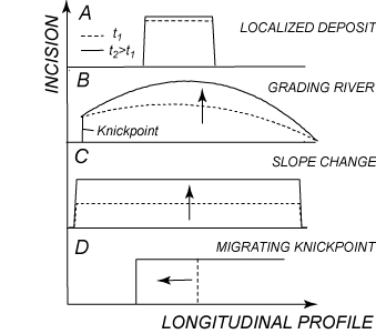
Figure 1. Styles
of fluvial incision of continental shelves. (A) Highstand deposits lead to a
localized incision that is proportional to the deposit thickness. (B) A river
out of equilibrium produces an incision that is maximum for an intermediate
location along the
river course; (C) an increase in slope in the shelf relative
to the river produces an uniform incision; (D) a sea level below the shelf
break triggers the formation of migrating knickpoints (after Fagherazzi et al.
2008).
Phase 2:
Determination of fluvial incisions in the Florida shelf during sea-level cycles In the second phase we applied the three-dimensional model
DELIM to the Northwest Florida shelf. The model simulates oscillations in sea
level, the exposition of the shelf surface to rainfall and subaerial agents,
and the incision of the shelf surface with the formation of several river networks
(Fig. 1). The planimetric development of the rivers is dictated by the shelf
topography and by the characteristics of the coastal processes that rework the
sediments along the coastline. The orientation of the channels partly follows
the direction of the average alongshore sediment transport produced by waves
and currents. The model allows determining possible locations of buried
paleochannels in the Florida shelf, which can contain natural resources like
oil and gas.
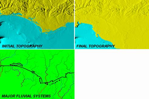
Figure 2.
Evolution of the Northwest Florida shelf after a decrease in sea level
reproduced with the model DELIM. The rivers extend until the new coastline
dissecting the shelf surface. The model indicates locations where buried
paleochannels can be found in the geological record.
Phase 3: Barrier
island evolution and related stratigraphy A fundamental characteristic of the Northwest Florida shelf
is the presence of barrier islands along the coast and their evolution during
glacioeustatic cycles. Barrier islands translate during sea-level rise
reworking the shelf substrate and determining the stratigraphic architecture of
the system. We developed a bidimensional numerical model (BIT, Barrier Island
Translation) to investigate the dynamics of a barrier island. The model is able
to simulate, under appropriate simplifying hypotheses, the evolution of the
barrier island profile at the geological timescale. The model imposes i) the
conservation of the total mass of sediments, ii) the conservation of the
equilibrium cross-shore beach profile on the plane parallel to the direction of
the wave action and iii) the translation of the beach equilibrium profile
according to the oscillations of mean sea level.
The wave action is divided into two components: a high
frequency one, which produces reworking of the seabed, and a low frequency one,
which is induced by extreme events like storms and hurricanes, and causes a
remarkable transport of sediments from the body of the sand barrier to the top
of the island and to the back barrier area. The model has been applied to Sand
Key,
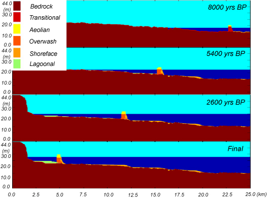
Figure 3. Representation of the shelf profile with the
barrier island of Sand Key, Florida. Six different facies are utilized in the
numerical model BIT (barrier island translation). The model simulates the
stratigraphic evolution of the system and its stratigraphy during the last 8000
years (after Masetti et al. 2008).