ACS PRF | ACS
All e-Annual Reports

45227-AC8
Geology and Paleontology of Coastal Angola
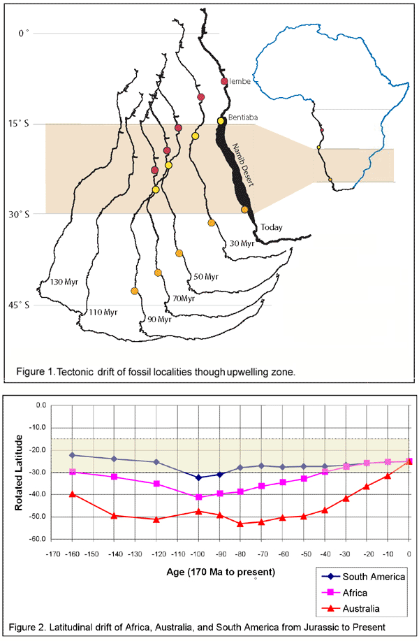
This project, jointly funded by the Petroleum Research Fund and the National Geographic Society, relates the occurrences of fossil vertebrates in Angola to the rocks in which they were found, and it relates the rocks to tectonic events involved in the opening of the South Atlantic, to the environmental conditions in which they were formed, providing an hypothesis for the generation of organic-rich hydrocarbon source rocks that occur extensively along the west coast of Africa. Our work was concentrated near Bentiaba at the northern limit of the Skeleton Coast in Namibe Province, and at Iembe in Bengo Province. We collected samples for isotopic analysis from measured stratigraphic sections and excavated fossil vertebrates. Export of samples and specimens from Angola was a delicate business, even though we are working collaboratively with colleagues from Aghostano Neto University, samples only having arrived recently, limiting the amount of isotopic data currently available. In addition, student Karen Gutierrez (recently graduated with honors, to begin graduate studies at the University of Michigan with a Sandia National Laboratory Scholarship) has analyzed sediment cores from the Congo River basin drilled in the 1960's and interpreted their mineralogy as a test of the hypothesis generated from Angolan field work. In the course of her work on this project, Ms. Gutierrez conducted field and laboratory work in Portugal and to examine the Congo cores at the Africa Museum, Tervuren, Belgium. In order to incorporate GIS into our field work, a program was written to enable refined use of geographic information such that field data for individual fossil discoveries, compiled in an spreadsheets, and exported as a comma-delimited file. The program, written in Python, parses the comma-delimited file and creates a Keyhole Markup Language (KML) file that can be used in Google Earth asnd other GIS programs for viewing the distribution of fossil localities. The Google Earth implementation provides collection data and images of the fossils via pop up windows. While the prediction of the location of organic-rich deposits has long been recognized as important in hydrocarbon exploration, our study underscores the importance of understanding continental positions and atmospheric circulation in predicting upwelling and organic production. Continental latitude and orientation is a first order determinant of climate because of unequal insolation, causing convective atmospheric Hadley cells, which control the distribution of moisture in subtropical latitudes. The distribution of climatically sensitive sedimentary rocks through geologic time indicates that the high latitude margin of the southern Hadley Cell has remained relatively constant in position. Anticyclonic subsidence results in aridity between approximately 15ş and 30şS. Southeasterly trade winds are drained of moisture as they pass over the continent, creating arid conditions leeward and inducing coldwater upwelling along western margins, bringing nutrients to the ocean surface and increasing marine organic productivity. Organic material produced at upwellings is captured in organic-rich marine source rocks. During the Cretaceous, the northern limit of the African Hadley Cell was marked by the paleolatitude of the Equatorial Convergence Zone recognized by organic rich deposits from Senegal to the Gulf of Guinea. The southern limit during the late Coniacian (86 Myr) lay at < 40şS. All Angolan fossil localities sampled a highly productive near-shore environment, as evidenced by the abundance and diversity of carnivorous vertebrates, especially marine amniotes. The locality of Fazenda dos Cavaleiros produces mosasaurs within a few meters of the Cretaceous-Paleogene boundary (65.5 Myr). Metamorphic clasts and dinosaur bones in the localities indicate proximity to shore. Sediments were derived from an arid source as indicated by the lack of plant debris or other organic matter and underlying terrestrial red alluvial fan deposits with dessication features and evaporites. Since the opening of the Atlantic, Africa has experienced counterclockwise and northward drift through the subtropical arid climate zone, bringing it through the productive upwelling zone, thereby explaining source rocks without recourse to global oceanic anoxic events, and allowing prediction for other land masses (Figure 1). Figure 2 traces tectonic drift during the last 160 million years for Australia, South America, and Africa, for 25°S degrees current latitude, the height of upwelling productivity. Atacama Desert of Chile and Peru is the oldest geographically stationary desert on Earth evidenced by Jurassic and younger shallow marine and terrestrial sedimentary rocks characteristic of arid environments, and offshore organic shales of upwelling origin. South America has shown little latitudinal drift thereby remaining stationary relative to the position of the descending limb of the Hadley Cell for 150 Myr. Australia, however, lay south of the arid paleolatitudes until about 10 Myr, coincident with geologic and biotic change.