www.acsprf.org
Reports: ND848729-ND8: Wind Erosion in the Qaidam Basin: Records, Rates, and Broader Implications
Liquid water and ice are the dominant agents of erosion and sediment transport in most actively growing mountain belts. An exception is in the western Qaidam basin along the northeastern margin of the Tibetan plateau where wind and wind-blown sand have sculpted enormous yardang fields (linear, streamlined bedrock ridges and parallel troughs) in actively folding sedimentary strata. This project aims to quantify the history of wind erosion in the Qaidam basin and its implications for tectonics, paleoclimate, and the source of the Loess plateau. Collaborators who obtained research funding from this project include Assistant Professor Richard Heermance at California State University, Northridge (stratigraphy and magnetostratigraphy), graduate students Alexander Rorhmann (cosmogenic isotopes) and Martin Pepper, postdoctoral researcher Alexander Pullen (U-Pb provenance studies), and undergraduate students Andrew McCallister, Alyssa Abbey, and Miles Hearn (assistance with sample preparation). Major findings are listed below and are presented in a publication in GSA Today (Kapp et al., 2011), a paper in Geology (Pullen et al., in press), and two manuscripts in final stages of preparation.
Major findings are listed below.
1. Investigations of Plio-Pleistocene Qaidam basin fill show that lacustrine sedimentation was punctuated by periodic episodes of sub-aerial exposure and wind erosion (including development of paleoyardangs) during glacial/stadial periods when central Asia was colder and drier.
2. Construction of geologic cross sections show that wind episodically removed strata from the western Qaidam basin at high rates (>0.12-1.1 mm/yr). Our analysis yielded a basin-wide average erosion/deflation rate of 0.29 mm/yr over the past 2.8 Ma. This rate overlaps with Quaternary erosion rates (locally, >0.3 mm/yr) that we quantified for the first time in the basin using cosmogenic nuclides. There are localized erosion hotspots above anticline crests where up to 3 km of strata have been removed, corresponding to an erosion rate of 1.1 mm/yr.
3. Chronostratigraphic age control, together with stratigraphic and stable isotope data, show the appearance of wind-erosion features, intensification of aridity, and accelerated fold growth (based on appearance of growth strata) all at 3.0-2.5 Ma, supporting the hypothesis that onset of wind erosion and aridity coincided with enhanced fold growth.
4. Analysis of Qaidam fold geometries and their relationship to the prevailing wind directions reconstructed from modern yardang orientations raises the additional possibility that wind erosion influenced fold geometry and kinematics. The regional shortening direction along the northeastern margin of the Tibetan plateau is NE-SW. Hence, we would expect the axial traces of Qaidam folds to trend NW-SE. However, in many places, axial traces trend more E-W than expected and many folds are crescent shaped in map view, with axial trace trends that vary from NW-SE to more E-W orientations. Many Qaidam anticlines are fault-propagation folds with steeper dipping forelimbs and shallower dipping backlimbs. For most Qaidam anticlines, the forelimbs are located on the northern sides of the axial traces, indicating that the anticlines are propagating northward to northeastward, roughly in the up-wind direction. We raise the possibility that northerly to northwesterly winds caused more erosion on the northern forelimbs, where winds were forced to move up and over the anticlines, relative to the backlimbs. This enhancement of erosion along the northern forelimbs might have facilitated northward fault propagation, which in turn would create a topographically more abrupt forelimb that would further enhance and localize wind erosion.
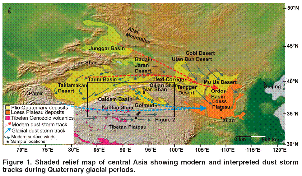
5. U-Pb ages of zircons in Loess Plateau loess suggest that this loess was derived not only from the Qaidam basin, but also from wind-eroded landscapes in the northern Tibetan plateau. This supports our hypothesis that the main axis of the polar jet stream was located ~10° closer to the equator (over the Qaidam Basin), as predicted by global climate models. It also strongly challenges the widely held view that the bulk of the Loess plateau deposits in China was sourced from the Gobi and adjacent sand deserts.
Collectively, our results transform current paradigms about the efficacy of wind as an erosion agent compared to liquid water and ice in some arid basin settings and its potential interaction with tectonics, and the history of paleoatmospheric circulation and dust production in Asia. This project was pivotal in allowing the principal investigator to pursue research avenues outside of his primary field of expertise in hard-rock structural geology and which span the fields of stratigraphy, geomorphology, tectonics, and paleoclimate. Without any hesitation, it is stated that this project has been the most intellectually stimulating and scientifically exciting part of the PI's career to date and that multiple new research directions for multiple people have been successfully established as a consequence of funding it.