Reports: AC8
46170-AC8 Absheron Allochthon: Evidence for South Caspian Seafloor Deformation in Response to Climatically Driven Hydrate Dissociation
Gas hydrates (also known as clathrates) consist of a gas molecule encased in a rigid lattice of hydrogen-bonded water molecules. Methane is the primary gas in most natural gas hydrates, with varying amounts of CO2, H2S, and other hydrocarbons including ethane and propane (Kvenvolden and Lorenson, 2001). The presence of gas hydrates has been inferred worldwide, forming in areas of high pressure and low temperature, typically on continental slopes and under arctic tundra. Due to the quasi-stable nature of gas hydrates they are difficult to sample directly, requiring a pressurized coring system (Abegg et al., 2008).
A large (>2,500 km2) late-Pleistocene zone of seafloor deformation and slumping, called the Absheron Allochthon (AA), has been imaged in the South Caspian Basin (SCB) using 2D (Diaconescu et al., 2000) and 3D seismic datasets. Since the history of sea level changes in the Caspian Sea in the past ~700 ka emphasizes a major ~100 m rise (Khvalyn transgression) and ~100 m drop (Yenotavian regression) in sea level during the late Pleistocene (Fig. 1) which would cause the expansion and subsequent dissociation of a massive gas hydrate reservoir, the emplacement of the AA was hypothesized to be related to the dissociation of gas hydrates. This research utilized 2D and 3D seismic data in conjunction with well data to place temporal constraints on the emplacement of the AA to evaluate whether this large-scale submarine slump could be related to the dissociation of gas hydrates. The study area is located in the NW region of the SCB (Fig. 2).
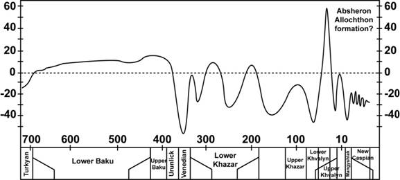
Figure 1. Sea level curve of the Caspian Sea for the last 700 kyr based on bio- and sequence stratigraphy as well as d18 O values (from Aliyeva, 2001). Note the non-linear time scale.
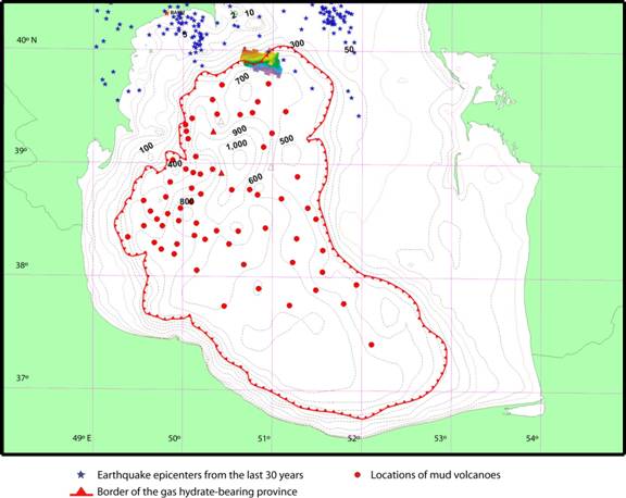
Figure 2. Map of the South Caspian Sea showing the locations of mud volcanoes and the outline of the gas hydrate-bearing province (from Ginsburg et al., 1992), as well as earthquake epicenters from the last 30 years (from NEIC database). The study area is shown with bathymetric colors near the northern border of the gas hydrate-bearing province.
The AA was mapped to be composed of two main facies components (Fig. 3); a chaotic facies component in the southwestern portion of the survey with discontinuous seismic reflections and relatively minor observable stratigraphic textures, and a continuous facies component in the northeastern portion of the survey displaying much more continuous seismic reflections which are interrupted mainly by normal faulting with some compressional features observed along the flanks of the mud volcano. These two facies are separated by a transitional zone displaying attributes from both components. The continuous facies component is stratigraphically thicker than the chaotic facies component.
The base of the AA displays a general terraced geometry consisting of relatively low-relief areas separated by steeply-dipping boundaries. The overall relief of the base of the AA is ~607 m, ranging from ~560 mbsl in the northwestern portion of the survey to ~1148 mbsl in the southeastern portion of the survey, and shallowing up to ~541 mbsl on the northern buttress of the mud volcano. The top of the AA displays more continuous relief, ranging from ~456 mbsl in the northern portion of the survey to ~753 mbsl in the southern portion of the survey, however locally the top of the AA displays a more erratic relief pattern than the base of the AA. An isopach map of the AA shows the thinnest sections of the AA (< 20 m) in the westernmost portion of the survey consisting of the chaotic facies component, while the thickest section of the AA (> 500 m) resides in the northeastern portion of the survey consisting of the more continuous facies component. The AA thins to ~20 30 m immediately surrounding the mud volcano, and is not observed directly overlying of this feature. From this isopach data, the volume of the AA within the survey area was calculated to be 155.88 km3.
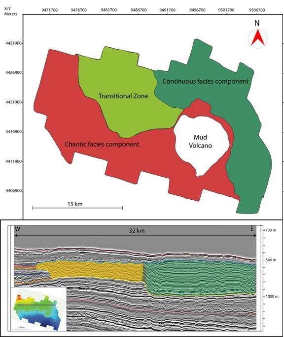
Figure 3. TOP: Distribution of AA facies. BOTTOM: Chaotic facies component (red) and continuous facies component (green) of the AA, separated by the transitional zone (yellow). An earlier stage of slumping is bounded by dark blue and orange horizons. The seafloor is denoted by the uppermost red horizon, and the Absheron series is denoted by the lowermost red horizon. Note the relatively undisturbed strata immediately above and beneath the AA. Seismic profile location shown atop seafloor bathymetry.
References
Abegg, F., H. J. Hohnberg, T. Pape, G. Bohrmann, J. Freitag. 2008. Development and application of pressure-core-sampling systems for the investigation of gas- and gas-hydrate-bearing sediments. Deep-Sea Research I, 55: 1590-1599.
Aliyeva, E. G. 2001. The newest stage of the Caspian Sea development: Bio- and sequence stratigraphy. Proceedings of Azerbaijan National Academy of Sciences, The Sciences of Earth, 1: 88-97.
Diaconescu, C. C., and J. H. Knapp. 2000. Buried Gas Hydrates in the Deepwater of the South Caspian Sea, Azerbaijan: Implications for Geo-Hazards. Energy Exploration and Exploitation, 18 (4): 385-4000.
Diaconescu, C. C., R. M. Kieckhefer, J. H. Knapp. 2001. Geophysical evidence for gas hydrates in the deep water of the South Caspian Basin, Azerbaijan. Marine and Petroleum Geology, 18: 209-221.
Diaconescu, C. C., and J. H. Knapp. 2002. Gas Hydrates of the South Caspian Sea, Azerbaijan: Drilling Hazards and Sea Floor Destabilizers. Paper presented at the 2002 Offshore Technology Conference, May 6-9, in Houston, Texas.
Ginsburg, G. D., R. A. Guseynov, A. A. Dadashev, G. A. Ivanova, S. A. Kazantsev, V. A. Solov'yev, E. V. Telepnev, R. Ye. Askeri-Nasirov, A. D. Yesikov, V. I. Mal'tseva, Yu. G. Mashirov, I. Yu. Shabayeva. 1992. Gas hydrates of the Southern Caspian. International Geology Review, 34 (8): 765-782.
Kvenvolden, K. A., and T. D. Lorenson. 2001. The global occurrence of natural gas hydrate. In Natural Gas Hydrates: Occurrence, Distribution, and Detection, ed. C. P. Paull and W. P. Dillon, 3-18. Washington D. C.: American Geophysical Union.