The purpose of this project is to study the tectonic
evolution of San Pedro
Basin (Fig. 1), offshore Southern California, using high-resolution seismic reflection data. San Pedro Basin has the morphology of a
pull-apart basin. However, a regional fault, the San Pedro Basin fault, cuts across the basin, a
characteristic unusual for a pull-apart basin.
The purpose of collecting seismic data was to map sedimentary sequences
to determine the history of the basin, including events such as the onset of
faulting.
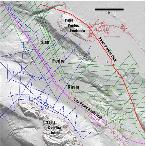
Figure 1: Bathymetric relief map of San Pedro Basin showing high-resolution seismic track
lines. Solid blue lines are data collected in 2008 as part of this project,
dashed blue lines were collected in 2009 (not yet processed). Solid green lines
are previously collected United States Geological Survey (USGS) data, and
dashed green lines are USGS data collected in summer 2009 (not yet
available).
San Pedro Basin
is in the California Continental Borderland, a continental margin area that
records a change in tectonic plate motion, from subduction
to transform motion, about 20 million years ago. Part of that area, the Inner Borderland, is
thought to be formerly subducted oceanic lithosphere
that was exhumed during a rifting episode associated with the change in plate
motion. The Inner Borderland consists of metamorphic basement overlain by
sediments deposited during the rifting episode. Imaging of these sediments and
their structure can provide insights into the evolution of plate motion.
Initially (2008), seismic lines were collected across the
basin and on the sediment-draped shelf east and north of Santa Catalina Island
(western boundary of San Pedro Basin;
Fig. 1, solid blue). These data clearly imaged the San Pedro Basin fault (Fig. 2), as well as a package of
multiple sequences surrounding the island and tilting away from it (Fig 3),
indicating uplift. The data were integrated with existing industry seismic (deeper
penetration but low resolution; Fig. 4), and multibeam
bathymetry, using Kingdom Suite, a 3D interpretation software package. This
allowed formulation of working hypotheses, and planning of the second summer's
(2009) data collection. The latter was completed just last month (September),
with more seismic collection on the Catalina shelf, and data in the northern
part of the basin to link to dated seismic profiles collected by other workers (Fig.
1, dashed blue). This modification of the original plan in
the proposal results from evaluation of the 2008 data, and consideration of
recently collected USGS data.
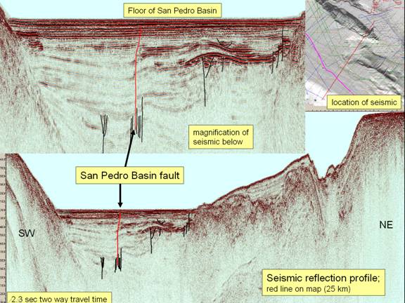
Figure 2
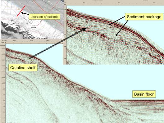
Figure 3
One preliminary result is that San Pedro Basin is not itself
a complete pull-apart basin but rather is a remnant of a former much larger
basin that has in places been inverted by pop-up or restraining bend structures
along strike slip faults such as the Palos Verdes fault. The eastern boundary
of San Pedro Basin is comprised of a tectonic block
that was uplifted, primarily in the last 600,000 years, along the Palos Verdes
fault. A thick sequence of largely unfolded sediments in San Pedro Basin appears to have been deposited during
this uplift while a deeper, folded sequence dates back several million years
and thus covers much of the interval of rifting of the Inner Borderland (Fig. 4).
It appears that the San Pedro Basin
and Palos Verdes faults may be related, possibly dynamically. The two faults converge
toward the southern end of San Pedro Basin, each has an associated set of subparallel folds, and one or more small faults link them
(Fig. 5). The San Pedro
Basin fault may have a relationship to the Palos
Verdes fault similar of that of the San Jacinto fault to the San Andreas fault, in which displacement formerly occurring along the
Palos Verdes fault is now being taken up along the San Pedro Basin fault.
Work from now on will focus on dating the sediments in the
basin, mapping and dating the package of sequences around the island, and from
information interpreting basin history, including testing of the above
hypotheses.
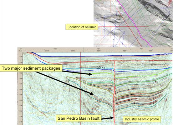
Figure 4
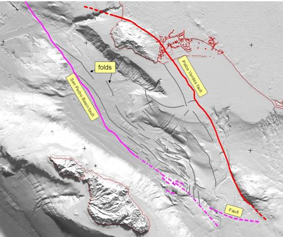
Figure 5
An undergraduate and a graduate student participated in the
2008 cruises. The undergraduate was supported by the grant in the first year to
interpret and map the seismic data using Kingdom Suite. Two more undergraduates
joined the project in August 2009, and one of these participated in the cruise
in September. During the cruises students see how seismic data are collected,
participate in deploying gear, in logging; and in preliminary processing. Currently there are three undergraduate
students supported by the grant and working on the project.
The first student hired said that experience with seismic
data and Kingdom Suite was valuable to him, as was the experience at sea. This
type of experience is a valuable addition to one's resume, especially as
Kingdom Suite is a petroleum industry-leading package. Another benefit, cited by the student, is the
experience of working on an actual scientific project, as opposed to something
in a class.
The impact of this project on my career has been significant.
It seems to be easier to obtain funding to procure equipment than for boat time.
From previous grants I have obtained a seismic energy source and a recently
developed digital multichannel seismic streamer; this advanced technology
enables me to collect the high-resolution images that are so valuable when used
with the existing deep-penetration industry data. I have been fortunate enough
to have one of the world's most expert practitioners and inventors in marine
seismic technology, Mike Barth (Subsea Systems, Ventura, CA),
as a participant in my cruises. The
funding of boat time from PRF has had a synergistic effect because of the
presence of these other resources, as well as the donation of Kingdom Suite to
CSULB. Now that the boat time has been
exhausted and the data collected, the main phase of interpretation begins.
Sufficient evidence already exists to indicate that a major change in our understanding
of San Pedro Basin, and perhaps of the Inner
Borderland, will occur. This will lead to preparation of a manuscript for
publication, presentations at meetings, and an ongoing research program with
future grants.